
Northeast Winter Storm Looks More Likely This Weekend, With Potential Nor’easter Bringing Heavy Snow From New York to Boston Sunday Into Monday
UNITED STATES — A winter storm is increasingly likely across the Northeast this weekend, with the potential for impactful snowfall from Sunday into Monday, especially near the I-95 corridor and coastal New England where heavier snow bands could develop.
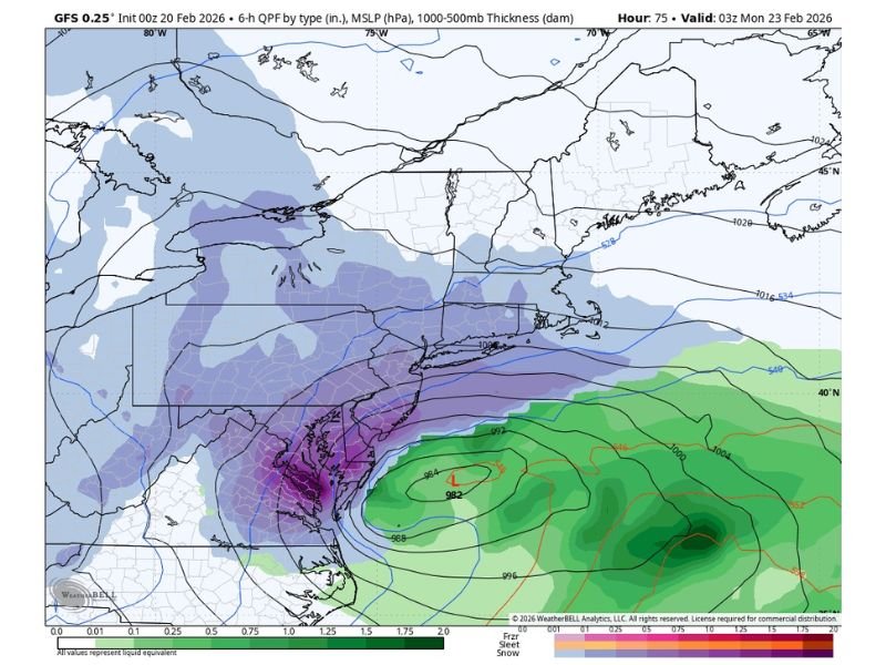
Forecast discussion tied to the latest model guidance notes growing confidence in a widespread area of accumulating snow, but the biggest question remains the storm’s exact track. If the developing low stays slightly offshore, snowfall totals could be more limited inland. If the low strengthens more quickly and tracks closer to the coastline, the system could evolve into a more classic Nor’easter, increasing snowfall intensity and adding stronger wind impacts for major metro areas.
Where Accumulating Snow Looks Most Likely
The current setup supports a broad snow shield across much of the Northeast, with the most meaningful impacts favored closer to the coast. The guidance highlights a corridor from the New York City region through southern New England, where a closer track would promote heavier rates and a higher chance for disruptive travel.
Cities specifically mentioned in the forecast scenario include:
- New York City
- Providence
- Boston
If heavier bands set up near and just inland from the coast, snowfall could become more intense over a shorter period of time, which is often when plowing struggles to keep up and roads deteriorate quickly.
Nor’easter Potential Depends on Track and Strength
At the heart of the forecast is whether the storm becomes a true Nor’easter-style coastal system. A stronger, better-organized low near the shoreline typically pulls in more Atlantic moisture and tightens the pressure gradient, which can increase both snowfall rates and wind impacts.
A slightly offshore track would likely keep the heaviest precipitation axis closer to the ocean, potentially reducing totals farther inland. A closer track, however, raises the risk that coastal and near-coastal communities see heavier, longer-lasting snow, with wind-driven blowing snow becoming a bigger factor.
Timing: Sunday Into Monday Could Be the Highest Impact Window
The current expectation places the most impactful period from Sunday into Monday, which is a high-risk timing window for travelers and commuters. Even without exact totals, the combination of accumulating snow and potential banding near major cities can produce widespread delays.
Residents across the Northeast should plan for fast-changing conditions, especially if the storm intensifies more rapidly than expected.
What Residents Should Do Now
With details still evolving, the best approach is preparation without overreacting to early totals. Helpful steps include:
- Monitor updates for changes in the coastal track
- Review travel plans for Sunday and Monday
- Charge devices and keep basic supplies ready
- Prepare for potential snow-covered roads and slower commutes
For more weather updates written in a clear, reader-focused format, keep following NapervilleLocal.com for developing coverage.

I’ve lived in Naperville long enough to see how quickly our community changes — from new developments downtown to sudden shifts in our Midwest weather. Reporting on Naperville news and daily forecasts gives me the chance to keep neighbors informed about what really matters. My goal is simple: deliver clear, timely updates so you always know what’s happening in our city and what to expect from the skies above.