
Northern Alabama Weather Alert: Cold Rain and Sleet Fall Across The Shoals, Hamilton, and Cullman as Temperatures Hover Near Freezing
NORTH ALABAMA — Residents across The Shoals, Hamilton, Cullman, and surrounding areas are seeing a wintry mix of sleet and cold rain Monday afternoon as frigid air moves into the region from Mississippi. Forecasters say temperatures are cold enough for snow higher up in the atmosphere, but a warm layer of air near the surface is preventing flakes from reaching the ground intact.
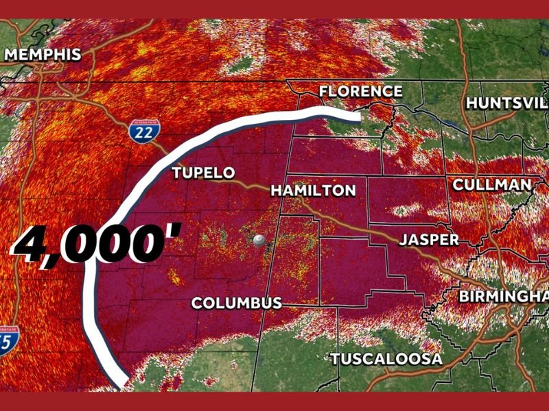
Meteorologists from WTM 13 First Warning Weather reported that snow or sleet is falling less than a mile away from parts of The Shoals, Hamilton, and Cullman, though most areas are only seeing rain at the surface.
Melting Layer Keeping Snow From Reaching Ground
According to the latest radar update around 4:00 p.m. Monday, the “melting height” — the level in the atmosphere where snowflakes melt into rain — sits at about 4,000 feet.
That means any snow falling above that level melts into liquid before hitting the ground, leaving most residents across Marion, Winston, Cullman, Lawrence, Franklin, Colbert, and Lauderdale counties with a steady cold rain instead of snow accumulation.
“It’s snowing less than a mile above the ground, but the warm air is just strong enough to keep it from making it down,” forecasters explained.
Temperatures Borderline for Wintry Mix
The air mass over northern Alabama is extremely cold aloft, but just warm enough at the surface to maintain a wintry rain. Meteorologists describe the last few thousand feet of air between the clouds and the surface as “the last mile,” and it’s currently holding just enough heat to prevent snow from fully forming.
That layer is only getting warmer overnight, meaning that areas seeing a light sleet mix this afternoon will likely transition back to all rain by late Monday evening and early Tuesday morning.
Rain Expected to Continue Through Tuesday Morning
The cold front continues pushing northeast out of Mississippi into north and central Alabama, bringing a raw, damp feel to much of the state. Despite air temperatures dropping into the upper 30s and low 40s, no major snow accumulation is expected overnight.
Meteorologists expect the system to weaken by early Tuesday, though patchy drizzle and lingering clouds could remain through the morning commute.
What’s Next
As this system exits, colder, drier air is expected to filter into the region midweek, setting up frosty mornings and highs struggling to reach the mid-40s in many locations. The combination of cold rain and overnight chill could lead to slick spots on bridges or elevated surfaces, especially in the higher elevations near Cullman and Winston counties.
Forecasters caution that while the region won’t see a significant snow event from this system, conditions remain favorable for additional winter precipitation later this week as Arctic air continues moving south.
Stay tuned for further updates from WTM 13 First Warning Weather and local meteorologists as temperatures fluctuate through midweek.
For continuing weather coverage and regional forecasts, visit NapervilleLocal.com.

I’ve lived in Naperville long enough to see how quickly our community changes — from new developments downtown to sudden shifts in our Midwest weather. Reporting on Naperville news and daily forecasts gives me the chance to keep neighbors informed about what really matters. My goal is simple: deliver clear, timely updates so you always know what’s happening in our city and what to expect from the skies above.