
Northern Georgia Braces for High-Impact Ice Storm as Freezing Rain Threatens Travel, Power, and Prolonged Cold This Weekend
GEORGIA — A high-impact ice storm is increasingly likely across northern Georgia this weekend, prompting forecasters to warn of dangerous travel conditions, widespread power outages, and lingering cold into early next week. Forecast confidence has grown as multiple weather models now agree that freezing rain — not snow — will be the primary and most dangerous threat, especially from Saturday into Monday morning.
Winter Storm Watch Expanded Across North and North-Central Georgia
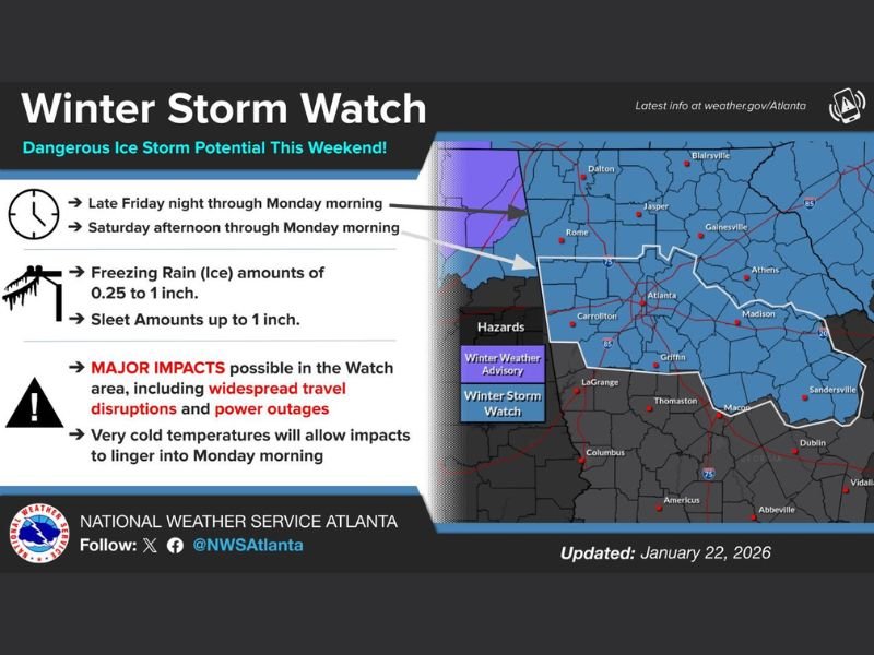
A Winter Storm Watch has been expanded to include most of northern Georgia and a portion of central Georgia, reflecting growing concern over significant ice accumulation.
The timing of the watch varies by location:
- Northern counties: 1 AM Saturday through 10 AM Monday
- Areas near and south of Interstate 20: 1 PM Saturday through 10 AM Monday
Forecasters stress that conditions may deteriorate rapidly, especially overnight when surface temperatures remain near or below freezing.
Ice Expected to Be the Primary Hazard
Model consensus now shows an exceptionally strong warm layer aloft, with temperatures near 50 degrees at roughly 5,000 feet, while surface temperatures remain at or slightly below freezing.
This setup strongly favors:
- Freezing rain as the dominant precipitation type
- Ice accretion on roads, trees, and power lines
- Minimal snow accumulation, aside from brief sleet or mixed precipitation at the onset
Snow totals have effectively dropped to near zero, shifting concern entirely toward damaging ice impacts.
Greatest Risk Zone Identified
The highest risk for significant ice accumulation includes:
- Atlanta metro area
- Athens and surrounding communities
- Much of north and north-central Georgia
These areas sit within the core of a cold-air damming wedge, a setup that allows cold surface air to remain trapped while warmer air flows overhead, maximizing freezing rain potential.
Travel Disruptions and Power Outages Likely
Forecasters expect widespread travel disruptions due to:
- Icy roads and bridges
- Rapid ice buildup on untreated surfaces
- Reduced visibility during heavier precipitation
Power outages are considered likely, as even moderate ice accumulation can bring down trees and power lines. Officials warn that outages combined with dangerous cold could significantly increase risk for residents.
Dangerous Cold to Follow the Ice
After the icing phase, very cold air is expected to surge into the region by Sunday night, with temperatures remaining well below normal into early next week.
This raises concerns that:
- Ice impacts may linger longer
- Roads could remain hazardous
- Power restoration may be slower
- Cold exposure risks increase, especially if outages occur
Why Forecast Confidence Is Increasing
Recent model updates, including improved atmospheric sampling, have reduced uncertainty. While earlier guidance briefly suggested a warmer or more northern track, newer data has realigned models toward a colder, more ice-focused solution.
Meteorologists now agree that significant ice accumulation is a realistic outcome, not a worst-case outlier.
Preparedness Is Strongly Encouraged
Residents are urged to:
- Avoid unnecessary travel during the storm window
- Review family emergency plans
- Prepare for extended power outages
- Have alternate heating sources ready
- Check on vulnerable neighbors
This is the type of winter storm where impacts are driven by ice, not snow totals, and conditions can worsen faster than expected. Stay informed, stay prepared, and continue following storm coverage and regional impact updates at NapervilleLocal.com as this dangerous Georgia ice storm unfolds.

I’ve lived in Naperville long enough to see how quickly our community changes — from new developments downtown to sudden shifts in our Midwest weather. Reporting on Naperville news and daily forecasts gives me the chance to keep neighbors informed about what really matters. My goal is simple: deliver clear, timely updates so you always know what’s happening in our city and what to expect from the skies above.