
Northern Indiana Braces for Major Lake-Effect Snow Event as Snow Squalls and Blizzard-Like Conditions Develop Today
INDIANA — A significant lake-effect snow event is ramping up across northern Indiana today, bringing snow squalls, rapidly deteriorating visibility, and the potential for major snowfall accumulations that could make travel dangerous or impossible in some areas through Thursday morning. Meteorologists warn that conditions will worsen quickly as a fast-moving snow squall pushes southward across the state, followed by persistent lake-effect snow bands fueled by strong winds off Lake Michigan.
Snow Squall Brings Sudden Whiteouts Across the State
A quick but intense snow squall is expected to sweep south through Indiana this morning, capable of producing 1 to 2 inches of snow in a very short time, potentially reaching as far south as the Interstate 70 corridor.
During the passage of the squall, residents can expect:
- Wind gusts of 30 to 40 mph
- Rapid drops in visibility to near zero
- Flash snow accumulation on roadways
- Sudden, hazardous driving conditions
Snow squalls are particularly dangerous because they strike with little warning, turning clear roads into slick, snow-covered surfaces within minutes.
Lake-Effect Snow Intensifies Behind the Squall
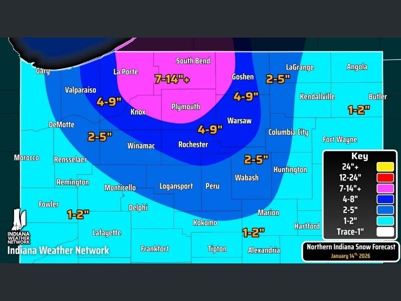
Behind the initial squall, strong northwest winds will continue, allowing lake-effect snow to rapidly intensify across northern Indiana counties. This snow is expected to persist throughout the day and into the overnight hours, with the heaviest bands lingering well into Thursday morning. By sunrise Thursday, some areas of northern Indiana could see between 4 and 14 inches of new snow, with localized amounts potentially exceeding those totals where snow bands remain stationary.
Heaviest Snow Focused Near Lake Michigan
Forecast data highlights a corridor of very heavy snow north and northeast of South Bend, where snowfall totals of 7 to 14 inches or more are expected. Surrounding areas may see:
- 4 to 9 inches across parts of north-central Indiana
- 2 to 5 inches extending farther south and east
- 1 to 2 inches near the southern edge of the snow shield
Forecasters note that this setup has the potential to overachieve, and while confidence is lower, isolated reports near 24 inches (2 feet) of snow cannot be ruled out if intense bands persist.
Thundersnow and Extreme Snow Rates Possible
Within the strongest lake-effect bands, snowfall rates could reach 1 to 2 inches per hour, especially late tonight into early Thursday. There is also the potential for thundersnow, a rare phenomenon that signals extremely intense snowfall. These conditions can lead to near-blizzard situations, even outside of officially declared blizzard warnings.
Travel Could Become Impossible in Hardest-Hit Areas
Officials urge residents in the heaviest snow zones to avoid travel beginning around midday, if possible. The combination of heavy snow, strong winds, and poor visibility is expected to cause:
- Treacherous road conditions
- Drifting snow and snow-covered highways
- Vehicle spinouts and stranded motorists
- Potential road closures
Emergency officials stress that travel during peak snowfall may become nearly impossible in the most intense bands.
Northern Indiana is entering a high-impact, potentially historic lake-effect snow event, with snow squalls, powerful winds, and prolonged heavy snowfall expected through Thursday morning. Conditions will change rapidly, and localized extremes are likely. Residents should prepare now, monitor updates closely, and avoid unnecessary travel in warned areas as this dangerous winter event unfolds.

I’ve lived in Naperville long enough to see how quickly our community changes — from new developments downtown to sudden shifts in our Midwest weather. Reporting on Naperville news and daily forecasts gives me the chance to keep neighbors informed about what really matters. My goal is simple: deliver clear, timely updates so you always know what’s happening in our city and what to expect from the skies above.