
Northern Indiana Storm Cluster Moves Toward Michigan at 45 MPH as Strong Thunderstorms Track Along and South of I-94
South Bend, Indiana — A pocket of strong to severe thunderstorms was progressing into northern Indiana as of 5:30 a.m. EST, with storms moving northeast at approximately 45 mph. The activity is expected to continue pushing into southern Michigan later today, primarily impacting communities along and south of the I-94 corridor.
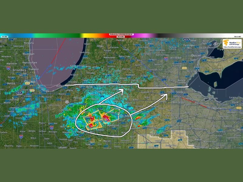
Radar imagery shows the most intense thunderstorms clustered across parts of north-central Indiana, including areas near Logansport, Peru, Wabash, and Huntington, where heavier downpours and embedded stronger cells have developed. The storms are tracking steadily northeast toward South Bend, Goshen, and eventually into southwestern Michigan.
Storm Motion and Timing
The storm complex is moving from the southwest to the northeast, advancing quickly at around 45 mph. Given that speed, conditions can change rapidly in communities directly in the path of the strongest cells.
The northeast motion places cities such as South Bend and La Porte in the short-term path, followed by areas across southern Michigan, particularly near and south of I-94, including cities like St. Joseph, Kalamazoo, and Battle Creek.
Forecasters note that while this setup is considered a low-end severe risk, it remains a risk nonetheless. Even marginal setups can produce localized damaging winds or brief severe warnings if storm intensity increases.
Where Strongest Storms Are Located
The heaviest activity early this morning is concentrated across portions of north-central Indiana, where radar returns show embedded stronger cores within a broader rain shield. These stronger cells may be capable of producing gusty winds and brief downpours, especially where thunderstorms intensify within the circled region shown on radar.
Communities near Huntington and Peru appear to be under the most organized cluster of storms at this hour. As this complex lifts northeast, it may hold together long enough to bring stronger impacts into southern Michigan later this morning.
Farther west, lighter rain and scattered activity stretch toward parts of northwest Indiana, though the more intense thunderstorms remain farther inland at this time.
What Michigan Can Expect Today
Strong to severe storms are expected in Michigan later today, primarily along and south of I-94. While the overall classification is considered a low risk, residents should remain weather aware, especially if storms maintain their current structure while crossing into the state.
Areas farther north of I-94 appear less likely to see severe impacts, though showers and occasional thunder cannot be ruled out.
Forecasters indicate that a four-panel severe weather outlook will be issued later this morning to provide further clarity on the evolving situation. If storms strengthen further, live tracking coverage is expected as conditions warrant.
Staying Weather Aware
With storms moving quickly at 45 mph, residents in northern Indiana and southern Michigan should ensure they have multiple ways to receive weather alerts, including mobile notifications and local media updates.
Even lower-risk severe setups can produce isolated warnings, particularly during morning transitions when instability increases. Monitoring updates throughout the morning will be important as this system continues to evolve.
For continued regional weather updates and developing storm coverage, stay connected with NapervilleLocal.com for the latest information.

I’ve lived in Naperville long enough to see how quickly our community changes — from new developments downtown to sudden shifts in our Midwest weather. Reporting on Naperville news and daily forecasts gives me the chance to keep neighbors informed about what really matters. My goal is simple: deliver clear, timely updates so you always know what’s happening in our city and what to expect from the skies above.