
Ohio and Southern Indiana Brace for First Thunderstorms of the Year as Cincinnati and Toledo Track Thursday Night Storm Line
OHIO — After days of bitter cold and blowing snow, a dramatic weather flip is setting the stage for the first thunderstorms of the year across parts of the Buckeye State. Forecasters say many Ohio communities could hear rumbles of thunder Thursday night as a storm system sweeps through the region.
High temperatures climbing into the 60s on Wednesday will mark some of the warmest air Ohio has felt so far this year. That surge of mild air will help fuel instability ahead of an approaching low-pressure system moving through the Midwest.
Warm Surge Sets the Stage for Storms
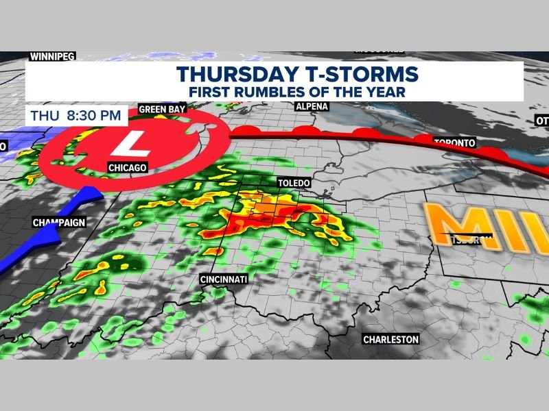
The developing system is centered near the western Great Lakes Thursday evening, with a trailing cold front stretching southwest toward Illinois and Indiana. As that boundary pushes east, showers and thunderstorms are expected to develop and expand across portions of Ohio.
While widespread severe weather is not currently anticipated, enough instability may exist to produce heavy downpours and loud claps of thunder. The contrast between recent winter chill and springlike warmth is helping energize the atmosphere.
Southwestern Ohio Most Likely to See Stronger Storms
Current projections suggest the strongest activity would be most likely in southwestern Ohio and into southern Indiana. Cities such as Cincinnati could see periods of steady rain and embedded thunderstorms Thursday evening.
Farther north, including Toledo and surrounding areas, storms may be more scattered but still capable of producing brief heavy rain and lightning. The timing appears to favor the evening and overnight hours as the cold front advances eastward.
If stronger cells are able to organize, gusty winds would be the primary concern. At this time, the overall severe threat remains limited, but conditions will be monitored closely.
A Sharp Change From Recent Winter Weather
The sudden jump from snow talk to thunder talk underscores how quickly late-winter patterns can shift across the Midwest and Ohio Valley. Just days ago, attention was focused on freezing temperatures and wind chills. Now, the focus turns to rain, lightning, and the first thunder of 2026. Even though this is not expected to be a major severe outbreak, it serves as an early reminder that storm season is not far away.
Residents across Ohio and southern Indiana are encouraged to stay weather aware Thursday evening, especially if traveling or planning outdoor activities. For continued updates on significant weather patterns affecting states across the country, stay connected with NapervilleLocal.com.

I’ve lived in Naperville long enough to see how quickly our community changes — from new developments downtown to sudden shifts in our Midwest weather. Reporting on Naperville news and daily forecasts gives me the chance to keep neighbors informed about what really matters. My goal is simple: deliver clear, timely updates so you always know what’s happening in our city and what to expect from the skies above.