
Ohio Braces for 30–35 MPH Wind Gusts Through Wednesday Morning, Spotty Rain or Snow Showers Possible in Miami Valley
OHIO — A developing weather system is set to bring gusty conditions across much of the state later today into Wednesday morning, with wind gusts reaching 30 to 35 mph, and isolated higher gusts possible in some locations.
Forecasters say the strengthening winds may be enough to blow around unsecured outdoor items, including trash cans and lightweight decorations.
Wind Speeds Climb Statewide
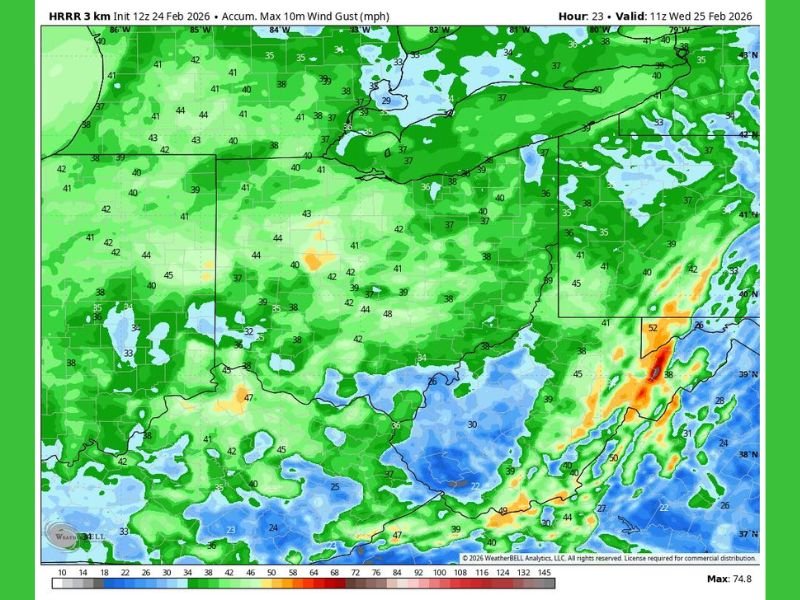
High-resolution model guidance shows widespread gust potential across Ohio and surrounding states through late Tuesday night into early Wednesday.
Wind gust projections indicate:
- Much of central and western Ohio: 30–35 mph
- Northern Ohio near Lake Erie: occasional gusts approaching 40 mph
- Southern and eastern Ohio: generally in the 30 mph range, with isolated higher pockets
The timing for strongest gusts appears to be from late afternoon Tuesday through early Wednesday morning as the system progresses east.
Miami Valley: Spotty Showers Possible
In addition to wind, a few rain or snow showers are possible in parts of the Miami Valley, including communities near:
- Dayton
- Troy
- Springfield
However, no significant accumulations are expected. Any precipitation that develops should be brief and light.
Travel and Safety Considerations
While this is not expected to be a damaging wind event, gusts in the 30–35 mph range can:
- Create minor travel challenges for high-profile vehicles
- Blow around loose objects
- Produce choppy conditions on open roads and elevated surfaces
Drivers are encouraged to use caution during the evening and overnight hours when winds may be strongest.
What Happens Next?
Conditions are expected to gradually calm later Wednesday as the system moves away. For now, the primary impact remains the gusty winds rather than precipitation.
Although this event is centered over Ohio, frontal systems like this often move east-to-west across the broader Midwest pattern. NapervilleLocal.com will continue monitoring regional weather systems that could eventually influence Illinois in the days ahead.

I’ve lived in Naperville long enough to see how quickly our community changes — from new developments downtown to sudden shifts in our Midwest weather. Reporting on Naperville news and daily forecasts gives me the chance to keep neighbors informed about what really matters. My goal is simple: deliver clear, timely updates so you always know what’s happening in our city and what to expect from the skies above.