
Ohio Braces for Strong Winds and Wintry Weather Tonight as Gusts Reach Up to 45 MPH Statewide
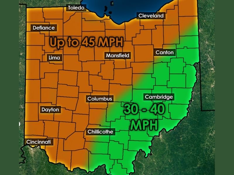
OHIO — A fast-moving system will bring strong winds, a wintry weather mix, and challenging travel conditions across much of the state from tonight into Wednesday. Meteorologists warn that wind gusts will range from 30 to 40 mph, with several regions, particularly central and western Ohio, likely experiencing gusts up to 45 mph.
Widespread Wind Gusts Expected Across the State
The strongest winds are forecast to affect cities such as Columbus, Dayton, Lima, Mansfield, Defiance, and Cincinnati, where gusts may approach the 45 mph mark.
Eastern and southeastern Ohio — including Cambridge, Canton, and Chillicothe — will still see significant winds, generally in the 30–40 mph range.
These wind speeds are strong enough to cause:
- Difficult driving for high-profile vehicles
- Scattered minor tree or limb damage
- Reduced visibility in areas experiencing snow or wintry mix
Wintry Weather Will Accompany the Winds
Alongside the strong gusts, forecasters expect rain, a wintry mix, and periods of snow from late Tuesday into Wednesday.
Snow showers and mixed precipitation could reduce visibility and make surfaces slick during the morning and midday hours.
Blustery and cold conditions will dominate Wednesday, even during breaks in precipitation, though winds will gradually ease by evening.
Travel Impacts Likely Through Wednesday
Transportation officials caution that the combination of strong winds and wintry precipitation may make travel hazardous, especially during the Wednesday morning commute.
Drivers are urged to:
- Allow for extra travel time
- Use caution on bridges and overpasses
- Monitor changing conditions through midday Wednesday
NapervilleLocal.com will continue to monitor and report on this developing weather pattern as Ohio faces strong winds and mixed winter weather through Wednesday afternoon.

I’ve lived in Naperville long enough to see how quickly our community changes — from new developments downtown to sudden shifts in our Midwest weather. Reporting on Naperville news and daily forecasts gives me the chance to keep neighbors informed about what really matters. My goal is simple: deliver clear, timely updates so you always know what’s happening in our city and what to expect from the skies above.