
Ohio Cities Including Dayton Springfield Xenia Troy and Greenville Face Thursday Night Heavy Rain Risk With 1 to 2 Inches Possible and Localized Flooding Concerns
DAYTON, OHIO — A developing weather system is expected to bring the risk of locally heavy rainfall across parts of western and central Ohio Thursday night into early Friday, raising concerns for potential localized flooding.
The threat comes alongside a broader severe weather setup, with storms possibly producing significant rainfall totals if they slow down or repeatedly move over the same areas.
Multiple Ohio Cities Included in Rain Risk Zone
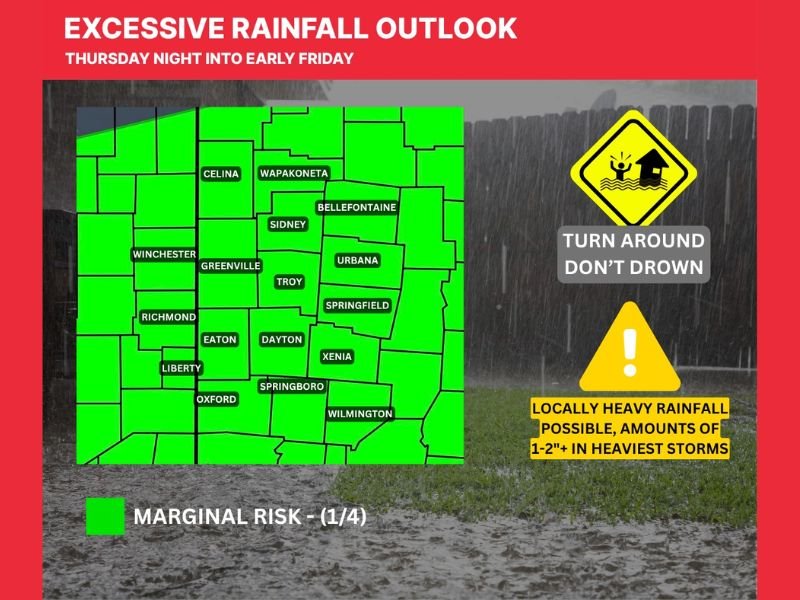
The highlighted risk area includes several communities across the region, including Dayton, Springfield, Xenia, Troy, Greenville, and Urbana.
Other impacted locations include Sidney, Bellefontaine, Wapakoneta, Celina, Wilmington, Eaton, Richmond, Oxford, and Springboro, all falling within the outlined rainfall zone.
Rainfall Totals Could Reach 1 to 2 Inches or More
Forecast guidance suggests that rainfall amounts of 1 to 2 inches or more are possible in the heaviest storms. These higher totals are most likely in areas where storms stall or move slowly, allowing rain to accumulate over a short period.
Flooding Risk Increases With Slow Moving Storms
The main concern with this setup is not just rainfall totals, but how quickly that rain falls. If storms repeatedly track over the same areas, localized flooding could develop, especially in low-lying or flood-prone locations.
Marginal Risk Level but Still Worth Monitoring
The current outlook places the region under a marginal risk for excessive rainfall, indicating isolated instances of flooding are possible. While not a widespread flooding event, localized impacts could still occur, particularly during heavier downpours.
Safety Reminder as Rain Moves In
Residents are urged to remain cautious, especially during periods of heavy rainfall. Driving conditions could become hazardous in areas where water collects on roadways, and the risk of flooding may develop quickly in certain spots.
What Happens Next
Forecast updates will continue to refine the timing and intensity of rainfall as the system approaches Thursday night.
Residents across Dayton, Springfield, Xenia, and surrounding Ohio communities should stay alert for changing conditions and potential advisories. Stay with NapervilleLocal.com for continued updates on this developing heavy rain threat and other weather impacts across Ohio and beyond.

I’ve lived in Naperville long enough to see how quickly our community changes — from new developments downtown to sudden shifts in our Midwest weather. Reporting on Naperville news and daily forecasts gives me the chance to keep neighbors informed about what really matters. My goal is simple: deliver clear, timely updates so you always know what’s happening in our city and what to expect from the skies above.