
Ohio Cleveland Toledo and Akron Under Elevated Storm Risk With Damaging Winds Hail and Isolated Tornado Threat This Afternoon Into Tonight
CLEVELAND, OHIO — Storms are expected to develop across northern Ohio this afternoon into tonight, bringing an elevated risk for damaging winds, hail, and even a low-end tornado threat across cities including Cleveland, Toledo, and Akron.
While not expected to become a widespread severe outbreak, the setup could still produce a few strong storms capable of localized impacts.
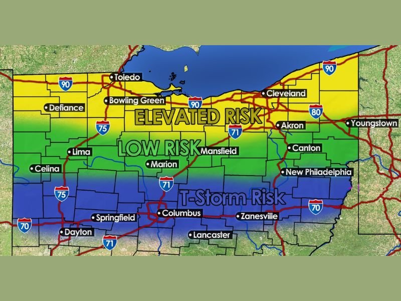
Elevated Risk Focused Across Northern Ohio
Forecast data highlights a corridor of higher concern stretching across northern Ohio, including:
- Toledo
- Bowling Green
- Cleveland
- Akron
- Areas along the I-90 corridor
This zone is marked under an elevated risk, meaning storms that form here have a higher chance of becoming strong or briefly severe.
Farther south, including areas like Mansfield, Marion, and Lima, the risk decreases to a lower tier, while Columbus, Dayton, and Springfield remain in a general thunderstorm zone.
Damaging Winds and Hail Lead the Threats
The primary hazards with today’s storms include:
- Damaging wind gusts capable of causing minor damage
- Hail up to quarter size in stronger cells
- A low-end tornado risk, especially with any storm that becomes more organized
Additionally, storms may bring heavy rain, increasing the potential for localized flooding in areas that receive repeated downpours.
Why This Is Not a Major Severe Outbreak
Despite the elevated risk, several limiting factors are in place:
- Instability remains modest, around 1,000 J/kg
- Wind shear is present but not extreme
- Moisture levels are high, contributing more to rain potential than explosive storm growth
This combination suggests storms will be capable but not necessarily widespread or long-lasting severe systems.
Timing and Storm Development
Storms are expected to:
- Develop during the afternoon hours
- Continue into the evening and nighttime
- Remain somewhat scattered, with only a few becoming strong
Because of this, impacts may vary widely from one location to another.
Residents Should Stay Alert for Changing Conditions
Even though the risk is not extreme, conditions could still produce isolated but impactful storms, especially later in the day.
Residents are encouraged to:
- Monitor weather alerts through the afternoon and evening
- Be prepared for sudden heavy rain and gusty winds
- Stay aware of rapidly changing conditions
A Setup That Could Still Surprise
This type of weather pattern is known for producing isolated strong storms that can catch people off guard, particularly when conditions appear calm earlier in the day.
Northern Ohio residents should remain weather-aware as storms begin to develop later today. Conditions will continue to be monitored as this system moves across Ohio. Stay with NapervilleLocal.com for continued weather updates and regional coverage.

I’ve lived in Naperville long enough to see how quickly our community changes — from new developments downtown to sudden shifts in our Midwest weather. Reporting on Naperville news and daily forecasts gives me the chance to keep neighbors informed about what really matters. My goal is simple: deliver clear, timely updates so you always know what’s happening in our city and what to expect from the skies above.