
Ohio Dayton Springfield and Xenia Under Marginal Storm Risk With Spotty Afternoon Cells Bringing Gusty Winds and Small Hail Near I 70 Corridor
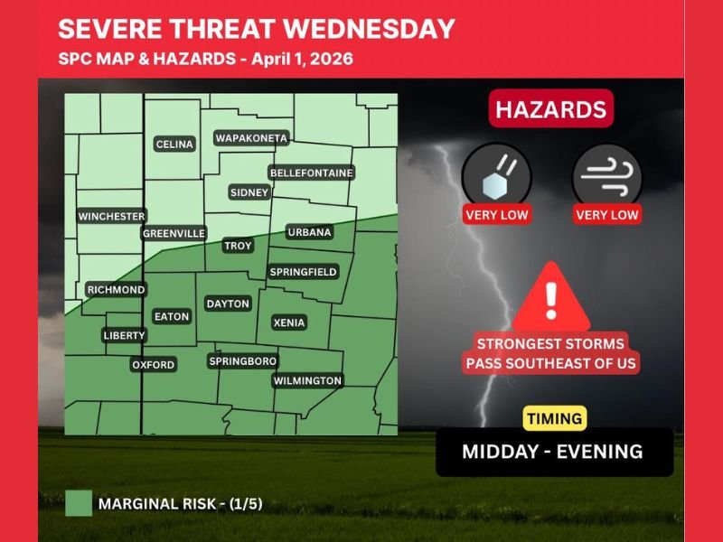
DAYTON, OHIO — A low-end severe weather threat is in place across parts of Ohio today, particularly near and south of the I-70 corridor, where a few spotty storms could develop from midday into the evening.
While widespread severe weather is not expected, isolated stronger cells could still bring brief impacts across communities including Dayton, Springfield, and Xenia.
Marginal Risk Covers Western and Central Ohio
Forecast data places much of western and central Ohio under a Level 1 Marginal Risk, including:
- Dayton
- Springfield
- Xenia
- Troy and Urbana
- Surrounding areas near the I-70 corridor
This classification indicates that while most storms will remain below severe limits, a few isolated storms could briefly strengthen.
Timing Focused From Midday Into Evening
Storm development is expected to follow a gradual timeline:
- Midday: Initial scattered showers begin developing
- Afternoon into evening: A few storms may briefly intensify
- Activity gradually diminishes later in the evening
This window suggests that any stronger storms will be short-lived and scattered in nature.
Limited Severe Threat With Falling Temperatures
Unlike more volatile setups, today’s environment features falling temperatures, which will limit overall storm intensity.
Key impacts may include:
- Small hail in isolated cells
- Gusty winds during stronger storms
- Brief rain showers and occasional thunder
The strongest storms are expected to pass southeast of the main coverage area, further reducing widespread risk.
Why This Setup Remains Low-End
Several factors are keeping the severe threat limited:
- Cooling temperatures reducing instability
- A slowly sagging front limiting storm organization
- Overall weaker atmospheric support compared to major outbreaks
This makes the setup more typical of isolated “rogue” storms rather than organized severe weather.
Residents Should Still Stay Aware
Even with a low-end risk, residents across areas such as Dayton, Eaton, Greenville, and Wilmington should remain alert for changing conditions during the afternoon.
Recommended precautions include:
- Monitoring local weather updates
- Being prepared for brief downpours and lightning
- Staying aware of any isolated stronger storm development
Spotty Storms Possible, But Widespread Impacts Unlikely
The overall pattern suggests scattered showers with only a few storms briefly reaching stronger levels, mainly during the afternoon and early evening.
While most areas will see minimal impact, a few localized storms could still surprise. Conditions will continue to be monitored as storms develop across Ohio today. Stay with NapervilleLocal.com for continued weather updates and regional coverage.

I’ve lived in Naperville long enough to see how quickly our community changes — from new developments downtown to sudden shifts in our Midwest weather. Reporting on Naperville news and daily forecasts gives me the chance to keep neighbors informed about what really matters. My goal is simple: deliver clear, timely updates so you always know what’s happening in our city and what to expect from the skies above.