
Ohio, Indiana, Kentucky Storms Exit Overnight as Severe Thunderstorm Watch Ends and Temperatures Crash Toward Freezing Across Miami Valley
DAYTON, OHIO — A line of strong to severe storms has moved out of the Miami Valley late Sunday night, bringing an end to the immediate threat as a sharp cold front sweeps through Ohio, Indiana, and Kentucky.
The Severe Thunderstorm Watch officially expired at midnight, and conditions are now rapidly stabilizing across cities including Dayton, Columbus, and Cincinnati.
Storm Line Pushes South and East Across Region
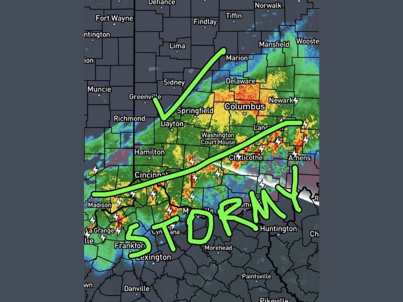
Earlier in the evening, a band of storms stretched from Indiana through Dayton, Springfield, Columbus, and into Chillicothe and Athens, producing heavy rain, lightning, and bursts of stronger activity.
The system steadily tracked from north to south, eventually pushing into parts of Kentucky and eastern Ohio before weakening. Areas west of the storm line, including parts of Indiana, have already cleared out, with calmer weather taking hold.
Severe Threat Ends Across Ohio Valley
With the expiration of the watch, the primary severe threats—including:
- Damaging wind gusts
- Large hail
- Frequent lightning
have now diminished significantly across the region.
While a few lingering showers may still be present in eastern areas, the organized severe weather risk has ended for the night.
Temperatures Set to Drop Rapidly Overnight
Behind the departing storms, a much colder air mass is quickly moving in across Ohio, Indiana, and Kentucky.
Temperatures are expected to fall sharply overnight, with many locations in the Miami Valley dropping to near freezing by early morning. This represents a dramatic shift from the warm, unstable air that fueled storms just hours earlier.
Chilly Start Expected for Monday Morning
By sunrise, residents in Dayton, Springfield, Columbus, and surrounding communities will wake up to noticeably colder conditions.
Light jackets or sweatshirts will likely be needed as temperatures hover near freezing in some areas, especially in lower-lying and rural locations.
The quick cooldown is a classic springtime pattern following a strong cold front.
Clear and Calm Conditions Return
As the system exits, skies will gradually clear, and winds will settle, leading to a quiet and stable weather pattern overnight into Monday. Travel conditions are expected to improve significantly after earlier storm-related disruptions.
What Comes Next
Looking ahead, no immediate severe weather threats are expected, as cooler and calmer conditions take over across the Ohio Valley.
Forecasters will continue to monitor for any additional changes, but the focus now shifts to the cooldown and recovery after a stormy end to the weekend.
Residents across Ohio, Indiana, and Kentucky can expect a much quieter start to the new week following this fast-moving system.

I’ve lived in Naperville long enough to see how quickly our community changes — from new developments downtown to sudden shifts in our Midwest weather. Reporting on Naperville news and daily forecasts gives me the chance to keep neighbors informed about what really matters. My goal is simple: deliver clear, timely updates so you always know what’s happening in our city and what to expect from the skies above.