
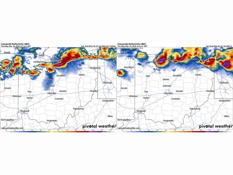
Ohio Indiana Pennsylvania Severe Storm Timeline Shows Two Rounds From Fort Wayne Toledo Cleveland With Nighttime Line After 9 PM
CLEVELAND, OHIO — A developing severe weather setup across Ohio, Indiana, and western Pennsylvania is showing a more complex timeline, with storms expected in two distinct rounds from the early evening into the overnight hours. Updated high-resolution models now indicate an earlier start followed by a stronger overnight system.
Round 1 Storms Expected Between Fort Wayne Toledo and Cleveland
The first wave of storms is expected to develop between 6 PM and 7 PM, stretching from Fort Wayne in Indiana through Toledo and into the Cleveland area in Ohio. This initial line appears stronger in newer model data than previously expected.
Storms during this phase could quickly intensify as they move east, impacting areas including Bowling Green, Findlay, and Sandusky. This early activity may cover a large portion of northern Ohio before sunset.
Early Storms Could Influence Overnight Threat
One key factor in this setup is how much the first round of storms impacts the atmosphere. If these early storms are strong enough, they could limit instability later in the night, especially near the Lake Erie shoreline.
However, if the atmosphere remains energized, conditions may still support a more organized and potentially stronger second round of storms.
Round 2 Main Line Moves Through After 9 PM
After the initial storms pass, a more organized line of severe weather is expected to develop and move through the region after 9 PM. This second round could impact a wider area, including Akron, Youngstown, and into parts of western Pennsylvania such as Meadville.
This overnight line has the potential to bring stronger wind fields and more widespread impacts depending on how the earlier storms evolve.
Strong Atmospheric Setup Supports Severe Potential
Forecast signals indicate strong southerly wind flow feeding into the region, which may help sustain storm strength longer into the evening. This setup could reduce interference from lake breeze boundaries and keep the environment favorable for severe weather. This means storms may maintain intensity as they move east across northern Ohio and into Pennsylvania.
Why Small Changes Could Have Big Impacts
This event highlights how minor changes in timing and storm placement can significantly alter outcomes. A shift of even an hour or slight repositioning of storm tracks could change which areas see the strongest impacts. Additionally, subtle influences like localized wind patterns or earlier storm intensity could reshape the overall threat.
What Residents Should Expect
Communities from Fort Wayne to Toledo, Cleveland, Akron, and into western Pennsylvania should stay alert through the evening and overnight hours. Conditions may change quickly as storms develop in multiple waves.
Residents are advised to monitor updates closely, especially during the evening transition period when the first storms begin to form. Stay with NapervilleLocal.com for continued updates, live weather tracking, and important alerts as this evolving severe weather situation unfolds across Ohio, Indiana, and Pennsylvania.

I’ve lived in Naperville long enough to see how quickly our community changes — from new developments downtown to sudden shifts in our Midwest weather. Reporting on Naperville news and daily forecasts gives me the chance to keep neighbors informed about what really matters. My goal is simple: deliver clear, timely updates so you always know what’s happening in our city and what to expect from the skies above.