
Ohio, Michigan Flood Threat Builds as 1–3 Inches of Rain Triggers Rising Water Across Toledo, Findlay, Fremont and Nearby Areas
NORTHWEST OHIO — Heavy rainfall across parts of Ohio and southern Michigan is rapidly increasing the risk of flooding, with several communities already seeing high water on roads after repeated rounds of storms over the past 24 hours.
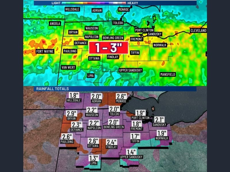
Over the last 12 to 18 hours, widespread rainfall totals between 1 to 3 inches have been recorded across areas including Toledo, Findlay, Bowling Green, Fremont, and Sandusky, with additional rain expected to continue through the weekend, raising concerns about flash flooding.
Rainfall Totals Already Saturating the Region
Radar estimates show consistent moderate to heavy rainfall stretching from Defiance, Bryan, Napoleon, and Ottawa eastward toward Norwalk and Mansfield, with localized pockets of heavier downpours.
Areas such as Paulding (2.6″), Bryan (2.9″), and Ottawa (2.6″) have already seen significant accumulation, while Toledo, Bowling Green, and Findlay are averaging near or above 2 inches.
This widespread saturation is making it increasingly difficult for the ground to absorb additional rainfall, leading to runoff and standing water issues.
Additional Rain Could Push Totals Higher
Forecast models indicate another 1 to 3 inches of rain is possible through the weekend, with some areas potentially seeing an extra inch in a single day.
Cities including Adrian and Monroe in Michigan, along with Port Clinton, Tiffin, and Upper Sandusky in Ohio, are expected to remain in the path of continued rainfall bands.
The repeated nature of these storms—often referred to as training thunderstorms—means the same areas could be hit multiple times, significantly increasing flood risk.
Flash Flood Risk Rising Across Key Corridors
With already saturated conditions, the threat of flash flooding is climbing steadily across the region.
Low-lying areas, poor drainage zones, and roadways are especially vulnerable, particularly in communities like Fremont, Norwalk, and Sandusky, where water accumulation can happen quickly. Drivers are being urged to use caution, as even small amounts of moving water can become dangerous.
What Residents Should Expect Next
The unsettled weather pattern is expected to persist through the end of the week, keeping the region under a continued flood watch scenario.
Emergency officials and weather teams are closely monitoring rainfall trends and runoff levels as conditions evolve. Residents should stay alert for rapidly changing conditions, especially during periods of heavier rainfall.
Final Outlook
With multiple rounds of rain already impacting the region and more on the way, northwest Ohio and parts of southern Michigan remain at heightened risk for flooding through the weekend. Officials will continue to monitor the situation closely as rainfall totals climb and storm activity persists.
For full reference of rainfall estimates and projections, see the original data here Stay connected with NapervilleLocal.com for continued updates as this developing weather situation unfolds.

I’ve lived in Naperville long enough to see how quickly our community changes — from new developments downtown to sudden shifts in our Midwest weather. Reporting on Naperville news and daily forecasts gives me the chance to keep neighbors informed about what really matters. My goal is simple: deliver clear, timely updates so you always know what’s happening in our city and what to expect from the skies above.