
Ohio Midweek Snowstorm Signal Strengthens as EURO Model Paints 5–9 Inches Across Northern Ohio
OHIO — A possible midweek snowstorm is drawing increased attention across Northern Ohio, as the European weather model (EURO) continues to amplify snowfall signals for the Wednesday night into Thursday time frame. While meteorologists stress this is not yet an official forecast, confidence is growing that a notable winter system could take shape if current trends hold.
Forecasters say the setup has been monitored closely for several days, with each new model run adding weight to the snow potential.
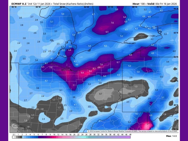
EURO Model Leads With Heavier Snowfall Scenario
The latest EURO runs are now consistently showing a broad swath of 5 to 9 inches of snow across Northern Ohio, indicating a potentially impactful winter storm if realized. This model has been steadily increasing projected totals, which has raised concern among forecasters given the EURO’s historical strength in handling complex winter setups. If verified, this would represent one of the more significant snow events of the season for parts of the region.
Other Forecast Models Support Snow, but With Lower Totals
While the EURO remains the most aggressive solution, other major models are also signaling snowfall, though at more conservative levels. Current projections from alternate guidance include 2 to 5 inches from the GFS model and 1 to 3 inches from the Canadian (GEM) model. This growing model alignment suggests the snow signal is not isolated, even if there remains uncertainty about exact placement and amounts.
Forecast Confidence Expected to Improve by Tuesday
Meteorologists caution that the evolving weather pattern remains messy, making it difficult to lock in final details this far out. Confidence is expected to increase significantly by Tuesday, when shorter-range data begins to refine storm track and intensity. Despite lingering uncertainty, forecasters note that the signal for snow continues to grow louder, particularly for northern portions of Ohio.
What Residents in Northern Ohio Should Watch For
If current trends continue, residents across Northern Ohio may need to prepare for potential travel disruptions, hazardous road conditions, and accumulating snow during the middle of the week. Timing appears focused on late Wednesday into early Thursday, though exact impacts will depend on storm evolution.
NapervilleLocal.com will continue monitoring this developing winter threat and provide updates as forecast confidence improves and official advisories are issued.

I’ve lived in Naperville long enough to see how quickly our community changes — from new developments downtown to sudden shifts in our Midwest weather. Reporting on Naperville news and daily forecasts gives me the chance to keep neighbors informed about what really matters. My goal is simple: deliver clear, timely updates so you always know what’s happening in our city and what to expect from the skies above.