
Ohio Pennsylvania West Virginia Maryland Indiana Severe Weather Threat Today Brings 60 MPH Winds Golf Ball Hail and Conditional Tornado Risk Across I 70 Corridor
OHIO VALLEY — A significant severe weather setup is unfolding today across parts of the Ohio Valley and northern Mid-Atlantic, with storms expected to develop this afternoon and intensify into the evening.
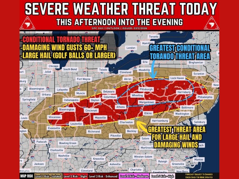
Forecasters warn that damaging winds, large hail, and a conditional tornado threat will be possible as a cold front moves through the region.
Storms Developing From Ohio Into Pennsylvania
Storm activity is expected to begin across eastern Ohio and western Pennsylvania, then spread eastward into areas including West Virginia, Maryland, and parts of the northern Mid-Atlantic.
Major cities in the impact zone include Columbus, Pittsburgh, Wheeling, Morgantown, and Harrisburg, with the most concentrated threat aligning near the I-70 corridor.
Damaging Winds and Large Hail Are Primary Threats
The main hazards with this system will be:
- Damaging wind gusts exceeding 60 mph
- Large hail, potentially golf ball size or larger
Some storms may evolve into supercells, which are capable of producing the most intense hail and wind impacts.
These conditions could lead to downed trees, power outages, and dangerous travel conditions during peak storm hours.
Conditional Tornado Threat Across Central Corridor
A conditional tornado threat is also present, particularly across a corridor stretching from central Ohio through western Pennsylvania into parts of West Virginia.
The tornado risk depends heavily on how much moisture returns ahead of the storms. If conditions become more favorable, a few storms could briefly rotate and produce weak tornadoes. While not everyone will experience this threat, it remains an important factor to monitor.
Timing From Afternoon Into Overnight Hours
The severe weather timeline is expected to unfold in stages:
- Afternoon: Initial storm development along the advancing cold front
- Late Afternoon to Evening: Stronger storms with peak hail and wind potential
- Evening to Overnight: Additional rounds of storms possible, though organization may decrease over time
As storms merge into clusters, the risk may shift more toward widespread wind damage rather than isolated severe cells.
Storm Organization May Limit Widespread Impact
Forecasters note that storms could become less organized as the system progresses, which may limit how widespread the most severe impacts become.
However, any storm that remains isolated longer could quickly intensify and produce localized severe conditions.
What Residents Should Do
Residents across Ohio, Pennsylvania, West Virginia, Maryland, and Indiana should stay alert throughout the day and evening.
Recommended precautions include:
- Monitoring weather alerts and radar updates
- Securing outdoor items ahead of strong winds
- Having a plan in place in case severe warnings are issued
Even though the tornado threat is conditional, the combination of hail and damaging winds makes this a notable severe weather event. Forecasters will continue to monitor conditions closely as storms develop later today, and residents are urged to stay informed.

I’ve lived in Naperville long enough to see how quickly our community changes — from new developments downtown to sudden shifts in our Midwest weather. Reporting on Naperville news and daily forecasts gives me the chance to keep neighbors informed about what really matters. My goal is simple: deliver clear, timely updates so you always know what’s happening in our city and what to expect from the skies above.