
Ohio Records Its Coldest Three-Week Stretch Since 1977 as Lake Erie Nears Full Ice Cover and Statewide Average Hits 14.3°F
OHIO — A brutal three-week cold stretch ending today has put all of Ohio into rare historical territory, with new statewide numbers showing the January 15–February 4, 2026 period averaged just 14.3°F when combining highs and lows. The data shared with the graphic describes it as the coldest three-week run in Ohio since the infamous winter of 1977, and notes that for many residents under 50, it’s the coldest sustained stretch they’ve experienced in the state.
What makes this cold stretch stand out across Ohio
This was not a “one-city” event or a small corner of the state getting hammered while others stayed closer to normal. The statement provided with the image emphasizes the cold was statewide, meaning the extreme conditions were felt broadly across Ohio communities—day after day—rather than tied to a single storm or brief Arctic blast.
Lake Erie ice coverage is rapidly closing in on 100%
One of the strongest real-world signals of how intense this cold has been is what’s happening on Lake Erie. The text says the lake is closing in on 100% ice coverage, a level that typically requires persistent, long-duration cold rather than a quick overnight freeze.
When a Great Lake starts approaching full ice cover, it’s a sign the region has been stuck in a deep freeze long enough for ice to expand and hold—even through daytime warming.
Ohio River seeing large ice floes as the freeze pushes south
The cold hasn’t been confined to the Great Lakes. The note also says the Ohio River is reporting large ice floes, with cold extending well south of that corridor. That matters because river ice is also driven by sustained cold and can become a major hazard for navigation, riverfront infrastructure, and shoreline conditions.
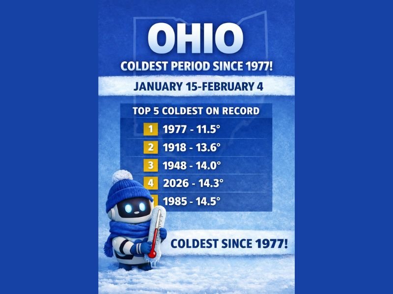
Where this ranks in Ohio history: Top 5 coldest on record
The graphic lists the Top 5 coldest three-week periods on record for Ohio, using the same “average of highs and lows” method for the Jan 15–Feb 4 window:
- 1977 — 11.5°F
- 1918 — 13.6°F
- 1948 — 14.0°F
- 2026 — 14.3°F
- 1985 — 14.5°F
That placement is the headline: 2026 ranks fourth-coldest, and the only period described as substantially colder is 1977.
What this means for people on the ground: cold damage risk doesn’t end when one storm ends
A three-week cold stretch can cause impacts that build over time, even without one “big blizzard” headline. When cold is that persistent, the risks often stack up in layers—frozen plumbing incidents, vehicle trouble, higher heating demand, and dangerous outdoor exposure—because there’s less opportunity for recovery days.
It also helps explain why ice expansion on Lake Erie and ice floes on the Ohio River become part of the story: prolonged cold doesn’t just chill the air, it changes the behavior of major water bodies.
Have you experienced unusual ice conditions or impacts from this cold where you live? Share what you’re seeing, and follow ongoing regional weather coverage at NapervilleLocal.com.

Naperville is a community with stories that deserve to be told — both the serious ones about safety and justice, and the lighter ones that capture our culture and daily life. I focus on covering crime reports and court updates while also highlighting the traditions, events, and social trends that shape who we are. Through my reporting, I want to give readers a fuller picture of Naperville — the challenges we face and the character that keeps our city strong.