
Ohio Severe Storms Shift From Toledo Cleveland Into Columbus With Northwest Ohio Threat Ending While Central Ohio Faces Hail Wind Risk
COLUMBUS, OHIO — Severe storms are moving out of northwest Ohio, bringing an end to the immediate threat around Toledo and surrounding areas, while the focus now shifts toward central Ohio where strong storms continue to push east.
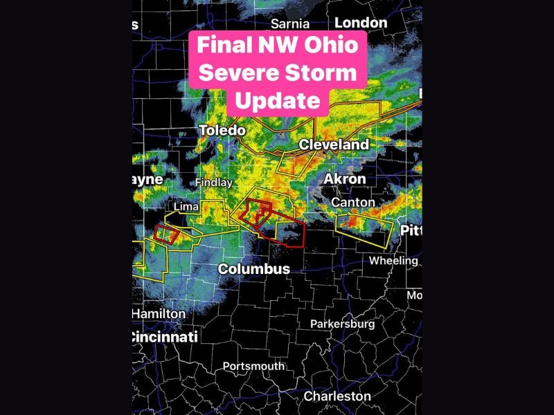
Northwest Ohio Threat Winds Down
Storm activity that earlier impacted areas near Toledo and Findlay is now weakening or moving out of northwest Ohio. This marks the end of the most intense phase for that region after several hours of active weather. Communities across northwest Ohio can expect improving conditions as the storm system continues eastward.
Strongest Storms Now Target Central Ohio
The main line of storms is now pushing into central Ohio, including areas near Columbus. Radar shows multiple clusters of storms continuing to produce heavy rain, lightning, and strong wind potential.
Some of the strongest cells are located just west and southwest of Columbus, indicating that the region remains under an active threat.
Hail and Damaging Winds Remain Primary Concerns
While the tornado threat appears limited, there is still some isolated potential as storms move through central Ohio. The primary hazards continue to be:
- Large hail
- Strong, potentially damaging wind gusts
- Intense rainfall and lightning
These impacts could cause localized damage and hazardous travel conditions.
Storm Line Extends Across Eastern Ohio
The broader storm system stretches eastward toward areas including Akron, Canton, and into parts of eastern Ohio. Additional storm clusters are also developing toward the Ohio-Pennsylvania border. This indicates that the severe weather risk is gradually shifting east rather than ending entirely.
What Residents Should Expect Next
Residents in central and eastern Ohio should remain alert as storms continue to move through. Conditions may change quickly, especially in areas directly in the storm path.
While northwest Ohio begins to clear, the severe weather threat remains active farther east into the evening hours. Stay with NapervilleLocal.com for ongoing updates, live radar coverage, and important alerts as this storm system continues across Ohio.

I’ve lived in Naperville long enough to see how quickly our community changes — from new developments downtown to sudden shifts in our Midwest weather. Reporting on Naperville news and daily forecasts gives me the chance to keep neighbors informed about what really matters. My goal is simple: deliver clear, timely updates so you always know what’s happening in our city and what to expect from the skies above.