
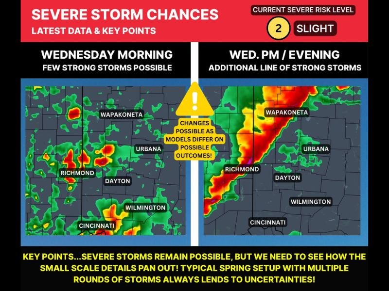
Ohio Severe Weather Setup: Two Rounds of Storms Possible Wednesday With Hail, Damaging Winds and Brief Tornado Risk
OHIO — Forecasters are monitoring a two-round severe weather setup expected to unfold across parts of Ohio on Wednesday, with storms potentially developing both in the morning and again during the afternoon and evening.
The latest forecast data indicates that multiple storm waves could move through the region, creating uncertainty about how intense conditions may become. Meteorologists say the exact strength of storms will depend on smaller atmospheric details that may not become clear until closer to the event. Despite the uncertainty, the environment appears capable of producing hail, damaging winds, and possibly a brief tornado in isolated areas.
First Round of Storms Possible Wednesday Morning
The first chance for stronger storms is expected before sunrise through mid-morning Wednesday, as isolated thunderstorms move northeast out of Indiana into western Ohio. These storms are expected to be scattered and somewhat isolated, but forecasters say they could still become locally strong.
Cities potentially affected during this early round include:
- Richmond
- Dayton
- Cincinnati
- Wilmington
- Urbana
- Wapakoneta
The primary concerns with the morning storms include small to moderate hail and gusty winds, though widespread severe weather is not currently expected during this first round.
Second Round May Bring Greater Severe Threat
A second, potentially stronger round of storms could develop Wednesday afternoon and evening, likely forming ahead of an approaching cold front. If the atmosphere becomes unstable between the morning storms and the arrival of the front, thunderstorms could organize into a line of stronger storms moving through the region after about 2 PM.
This second round is currently expected to carry the higher severe weather risk, with the following threats possible:
- Damaging wind gusts
- Large hail
- A brief tornado or two
Communities from Cincinnati through Dayton toward Urbana and Wapakoneta could see storms develop or move through during the afternoon and evening hours.
Forecast Uncertainty Remains
Meteorologists emphasize that this type of spring storm setup often contains uncertainty because multiple rounds of storms can influence each other.
If the morning storms linger longer than expected, they could limit the instability needed for stronger storms later in the day. On the other hand, if the atmosphere recovers quickly, the afternoon storms could intensify more rapidly. Because of these variables, forecast models may continue to shift over the next 24 hours.
Residents Encouraged to Monitor Updates
While the overall severe weather risk currently remains at a slight level, residents across western and central Ohio are encouraged to keep monitoring forecast updates as Wednesday approaches.
Having weather alerts enabled and staying aware of potential changes will be important, especially if the second round of storms develops as currently projected. Meteorologists say the key takeaway is that multiple storm rounds are possible, and the second wave later Wednesday could bring the more impactful severe weather if conditions align.

I’ve lived in Naperville long enough to see how quickly our community changes — from new developments downtown to sudden shifts in our Midwest weather. Reporting on Naperville news and daily forecasts gives me the chance to keep neighbors informed about what really matters. My goal is simple: deliver clear, timely updates so you always know what’s happening in our city and what to expect from the skies above.