
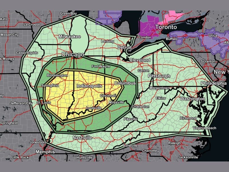
Ohio Valley Severe Weather Risk Expands Toward Indiana and Kentucky With Damaging Winds, Hail, and Tornado Threat Thursday
Indianapolis, Indiana — A developing severe weather threat is expected to impact much of the Ohio Valley on Thursday afternoon and evening, with forecasters highlighting the potential for damaging winds up to 60 mph, large hail, and a few tornadoes. The greatest concern appears centered over central and southern Indiana, northern Kentucky, and western Ohio, including major cities such as Louisville, Lexington, Cincinnati, Columbus, and Indianapolis. Storms are projected to move from west to east, intensifying through the late afternoon hours.
What the Severe Weather Setup Looks Like
Forecasters describe Thursday’s environment as an “all hazards” severe weather setup, meaning multiple types of dangerous weather could occur. The primary threat is expected to be damaging straight-line winds, with gusts potentially reaching or exceeding 60 mph. These winds are strong enough to bring down tree limbs, cause scattered power outages, and create hazardous travel conditions.
In addition to wind, large hail — potentially up to quarter-size in diameter — may develop in stronger storm cells. While hail typically impacts smaller areas compared to wind, it can still dent vehicles, damage roofs, and pose risks to outdoor events.
There is also the possibility of isolated tornadoes, particularly in areas where storm rotation becomes more pronounced. Although not everyone in the risk zone will experience tornado activity, forecasters stress that even a brief spin-up tornado can cause localized damage, especially in communities along and south of the I-70 corridor.
Areas Facing the Highest Risk
The most significant severe weather zone appears focused on central and southern Indiana, including Indianapolis, Bloomington, Terre Haute, Evansville, and Lafayette. Parts of northern Kentucky, including Louisville and Lexington, are also within the stronger risk zone. Farther east, cities such as Cincinnati, Columbus, and Charleston remain under a broader severe weather outlook.
Northern Indiana — including areas closer to South Bend and Fort Wayne — remains within a risk area, though the threat there is expected to be more isolated and somewhat lower compared to regions farther south.
Storms are forecast to develop and organize during the afternoon, with the most active timeframe between 2:00 PM and midnight Eastern Time on Thursday, February 19th, 2026. Residents across the region are encouraged to monitor updates throughout the day as conditions evolve.
Why This System Matters for the Region
The atmospheric ingredients appear favorable for storm development. Meteorologists note a combination of wind shear, instability, and sufficient moisture, which together can support rotating thunderstorms capable of producing wind damage and tornadoes.
One key factor in this setup is the highly sheared environment, meaning winds at different levels of the atmosphere are moving at varying speeds and directions. This increases the likelihood that storms can rotate and sustain strength as they move northeast across the region.
While not every storm will become severe, even a handful of strong cells could create pockets of impactful weather. Residents in the highlighted zones should ensure they have multiple ways to receive weather alerts, including weather radios, mobile notifications, and local broadcasts.
How Residents Should Prepare
With storms moving from southwest to northeast at approximately 40–50 mph, conditions may change quickly once warnings are issued. Preparation steps include securing loose outdoor objects that could become airborne in strong winds, reviewing tornado safety plans at home and work, charging electronic devices in case of power outages, and identifying safe interior shelter locations away from windows.
Officials emphasize that quick action during warnings can significantly reduce risk. Even short-lived severe weather events can produce damage when communities are caught off guard.
As forecast models continue to refine the storm track overnight and into Thursday morning, updates may adjust the highest risk corridor slightly north or south. Residents throughout the Ohio Valley region should remain alert.
For continued updates on major regional weather developments and how they may affect surrounding communities, visit NapervilleLocal.com for the latest reports and in-depth coverage.

Naperville is a community with stories that deserve to be told — both the serious ones about safety and justice, and the lighter ones that capture our culture and daily life. I focus on covering crime reports and court updates while also highlighting the traditions, events, and social trends that shape who we are. Through my reporting, I want to give readers a fuller picture of Naperville — the challenges we face and the character that keeps our city strong.