
Oklahoma and North Texas Face a Dry 15-Day Stretch, With Tulsa Near 0.09″ and Oklahoma City Near 0.00″ While El Niño Could Flip Late Spring Wetter
OKLAHOMA — A new 15-day projected rainfall outlook is raising short-term concerns for parts of the southern Plains, showing very limited rain totals across Oklahoma and portions of north and central Texas, even as some forecasters suggest the broader pattern could turn wetter later this spring if El Niño develops as expected.
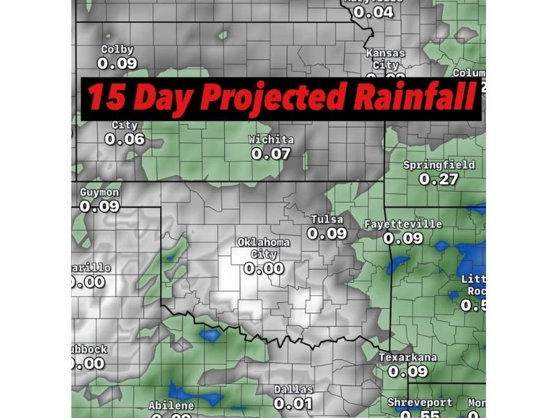
The map highlights a notably dry signal centered on Oklahoma, where several key cities show totals close to zero. Oklahoma City is shown near 0.00″, while Tulsa sits near 0.09″, indicating that meaningful, widespread soaking rain may be hard to come by in the next two weeks. Dallas is shown near 0.01″, reinforcing the idea that the dry pocket extends into parts of Texas as well.
What the 15-Day Rainfall Projection Shows Across the Region
The rainfall projection depicts a broad area of light or minimal precipitation for the next 15 days across Oklahoma and nearby states, with only isolated pockets showing slightly higher totals.
City totals shown on the map include:
- Oklahoma City: 0.00″
- Tulsa: 0.09″
- Dallas: 0.01″
- Wichita: 0.07″
- Fayetteville: 0.09″
- Springfield: 0.27″
- Texarkana: 0.09″
- Houston: 0.20″
- San Antonio: 0.06″
- Abilene: 0.09″
- Kansas City: 0.06″
- Colby: 0.09″
- Guymon: 0.09″
The takeaway from these numbers is not that rain disappears entirely, but that the region may see spotty, light events rather than repeated systems capable of producing widespread relief.
Why This Short-Term Dry Signal Matters
A two-week stretch with limited precipitation can matter quickly for soil moisture, early-season vegetation, and fire-weather concerns, especially if warmer temperatures and wind increase evaporation.
When projected totals hover around a tenth of an inch—or in the case of Oklahoma City, essentially zero—it often means:
- Topsoil dries out faster, stressing lawns and early planting
- Small creeks and ponds drop, particularly in rural areas
- Outdoor burning and grass fire risk can increase during breezy periods
- Communities relying on periodic rainfall may need to plan for continued dryness
Even where totals are slightly higher—like Springfield at 0.27″ or Houston at 0.20″—the numbers still suggest rainfall may not be frequent enough to offset ongoing dryness in other places.
Could El Niño Bring a Wetter Turn Later This Spring?
The commentary attached to the outlook notes that while the short-term trend looks unfavorable, a developing El Niño pattern could support a wetter late spring.
That does not guarantee rain in any one week, but it reflects a possible shift in the broader storm track later in the season. For now, the immediate focus remains on the next 15 days, where the signal points toward limited rainfall and a need for close monitoring. For more weather updates explained clearly with regional context, visit NapervilleLocal.com.

I’ve lived in Naperville long enough to see how quickly our community changes — from new developments downtown to sudden shifts in our Midwest weather. Reporting on Naperville news and daily forecasts gives me the chance to keep neighbors informed about what really matters. My goal is simple: deliver clear, timely updates so you always know what’s happening in our city and what to expect from the skies above.