
Oklahoma and Texas Brace for Sharp Temperature Drop as Windchills Fall Into the 0s, 10s and 20s Sunday Night
Oklahoma — After a stretch of record warmth, residents across Oklahoma and Texas are preparing for a sudden and dramatic return to winter weather as an Arctic air mass sweeps into the region late Sunday into early Monday. Meteorologists warn that temperatures will fall sharply by Sunday night, with windchill values dropping into the 0s, 10s and 20s across much of both states.
Arctic Cold Front Set to Replace Weekend Warmth
Forecasters report that unusually warm temperatures will hold through the weekend before a powerful cold front pushes through the Southern Plains. The front will bring a rapid shift from mild, spring-like conditions to winter-level cold within hours.
The core of the coldest air will settle over Oklahoma first, before spreading south through Texas by late Sunday night. Maps show a dramatic spread in windchill values, with some northern regions experiencing below-freezing air before midnight. The dramatic change follows several days of above-average warmth that allowed daytime highs to climb far higher than typical late-December levels.
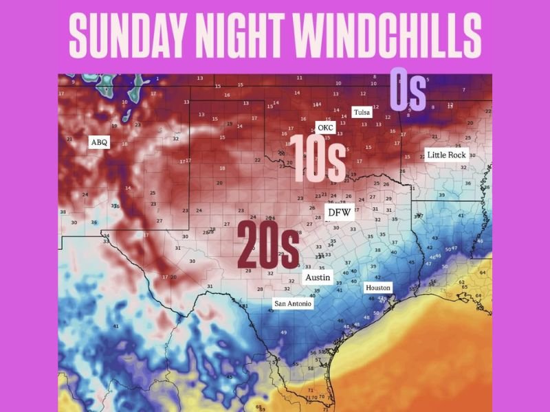
Forecast Windchills for Major Cities Across Both States
Sunday night’s windchill projections show a widespread drop across the entire region. Key forecast values include:
- Oklahoma City: 10s
- Tulsa: 13–14°F
- Dallas–Fort Worth (DFW): Low to mid-20s
- Austin: Around 23–26°F
- San Antonio: Upper 20s to low 30s
- Houston: Mid-30s
- Little Rock (neighboring Arkansas): Near 30°F
Northern Oklahoma and portions of far north Texas may briefly experience windchills in the single digits or 0s, particularly before sunrise Monday. Across West Texas and the Panhandle, temperatures will likely fall even faster, with early model guidance showing widespread 20s and low teens in areas near Amarillo, Lubbock and Wichita Falls.
Travel and Outdoor Risks Expected Overnight
With such a sharp transition, residents are urged to take precautions, especially those traveling late Sunday or early Monday. Strong winds behind the front will amplify the cold, making outdoor exposure more dangerous than temperatures alone would suggest.
Officials recommend that families prepare for:
- Cold windchills during early commutes
- Elevated risk of hypothermia for anyone outdoors without proper layers
- Higher heating demand in homes overnight
- Potential stress on livestock, pets and exposed pipes
While snow is not forecast in the majority of regions included in this update, the sudden cold can still cause disruptions and discomfort during the first hours of the workweek.
Central and Southern Texas Will Feel the Cold by Monday Morning
Although southern areas such as Houston, San Antonio and Corpus Christi will avoid the worst of the Arctic air, the shift will still be noticeable. Overnight windchill values in these regions are expected to fall into the 30s, a stark contrast from daytime temperatures that may reach the 70s before the front arrives.
The front’s speed will determine how far and how quickly the cold spreads, but the overall pattern signals a decisive end to the brief warm spell that has dominated the region. For continued nationwide weather updates, Arctic outbreak alerts and travel-impact forecasts, visit NapervilleLocal.com.

I’ve lived in Naperville long enough to see how quickly our community changes — from new developments downtown to sudden shifts in our Midwest weather. Reporting on Naperville news and daily forecasts gives me the chance to keep neighbors informed about what really matters. My goal is simple: deliver clear, timely updates so you always know what’s happening in our city and what to expect from the skies above.