
Oklahoma and Texas Face Dangerous Wind Event Friday as 40–55 MPH Gusts Raise Extreme Fire Risk
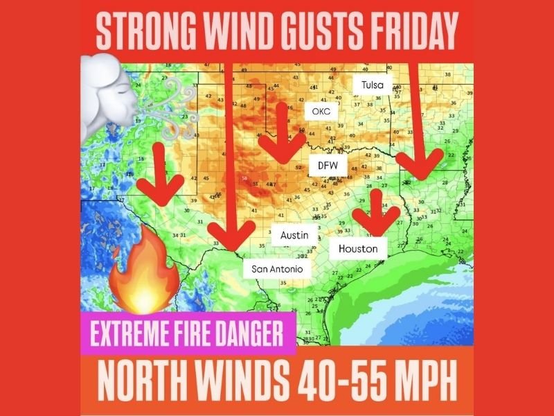
United States — A powerful wind event is expected to impact Oklahoma and Texas on Friday, as a reinforcing surge of colder air drives widespread north winds of 40 to 55 miles per hour, creating dangerous conditions and an elevated to extreme wildfire risk across much of the region.
Forecast guidance shows the strongest winds developing behind the advancing cold push, with sustained gusts strong enough to down tree limbs, disrupt travel, and rapidly spread fires in dry areas.
What Is Driving the Strong Winds
The expected wind surge is tied to a reinforcing blast of chilly air moving south through the Plains. As pressure rises sharply behind the front, winds accelerate across a broad area, especially over open terrain.
Key elements of the setup include:
- Strong north winds spreading south through Oklahoma into Texas
- Widespread gusts near 40 mph, with isolated gusts exceeding 50 mph
- A large geographic footprint, not a localized wind pocket
This type of setup often produces hours of sustained hazardous winds, rather than brief gusts.
Areas Most at Risk Friday
The highest wind potential covers much of central and western Oklahoma and large portions of Texas, including North Texas and areas extending south toward Central and South Texas.
Urban areas may experience:
- Difficult driving conditions for high-profile vehicles
- Blowing dust reducing visibility
- Power interruptions from downed lines or limbs
Rural and open areas face an even greater risk due to uninterrupted wind flow and dry ground conditions.
Extreme Fire Danger Expected
One of the most serious concerns associated with this event is extreme wildfire risk. Strong winds combined with dry fuels can allow fires to ignite easily and spread uncontrollably.
Fire-weather concerns include:
- Rapid fire spread even from small ignition sources
- Difficulty controlling existing fires
- Increased danger from outdoor burning, sparks, or equipment use
Officials often urge residents to avoid any activities that could produce flames or sparks during these conditions.
What Residents Should Do to Prepare
Residents across Oklahoma and Texas should take precautions ahead of Friday’s wind event, including:
- Securing loose outdoor items
- Avoiding open burning or outdoor welding
- Exercising caution while driving, especially in high-profile vehicles
- Staying alert for fire weather statements or wind advisories
Conditions may worsen quickly once winds strengthen, leaving little time to react.
For continued updates on hazardous weather events, fire-risk alerts, and regional safety information, follow coverage from NapervilleLocal.com, where we track significant national weather threats and explain why they matter.

I’ve lived in Naperville long enough to see how quickly our community changes — from new developments downtown to sudden shifts in our Midwest weather. Reporting on Naperville news and daily forecasts gives me the chance to keep neighbors informed about what really matters. My goal is simple: deliver clear, timely updates so you always know what’s happening in our city and what to expect from the skies above.