
Oklahoma and Texas Panhandles Could See Brief Light Snow or Rain-Snow Mix Late Thursday Night Into Early Friday
OKLAHOMA – Forecast guidance is showing an increasing signal for a brief period of light snow or a rain-snow mixture late Thursday night into early Friday across the Oklahoma and Texas Panhandles, according to the latest weather data. While impactful snow accumulations are not expected at this time, the situation is being monitored as colder air briefly interacts with available moisture.
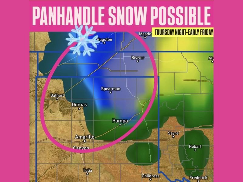
The forecast graphic highlights portions of the Panhandle region where precipitation may transition from rain to snow, especially during the overnight hours when temperatures are coolest. This setup favors light precipitation, rather than a widespread or disruptive winter event.
Timing Focused on Late Thursday Night Into Friday
The potential window for winter precipitation appears limited, with Thursday night through early Friday identified as the most likely timeframe. This suggests that any snow or mixed precipitation would be short-lived, occurring mainly overnight before conditions improve.
Because the signal is brief, daytime impacts are expected to be minimal, and no significant travel disruptions are currently anticipated based on available data.
Areas Most Likely to See Snowflakes
The circled area on the forecast image centers on parts of the Oklahoma and Texas Panhandles, indicating where colder air may be sufficient to support snowflakes mixing in with rain. Locations within this zone could experience light snow, flurries, or a rain-snow mix, depending on local temperatures at the time precipitation moves through.
The data does not suggest a uniform event across the region, meaning some communities may see precipitation while others remain dry or rain-only.
Accumulations Not Expected to Be Impactful
At this stage, impactful accumulations are not expected, which is an important distinction. Forecast guidance does not show enough intensity or duration to support measurable snowfall totals that would significantly affect roads or infrastructure.
However, forecasters note that this type of setup will continue to be monitored, as small temperature changes can influence whether precipitation falls as rain or snow.
What Residents Should Watch For
Residents in the Panhandles should remain aware of overnight temperature trends, especially if traveling late Thursday night or early Friday morning. Even light snow or a brief mix can occasionally lead to slick spots on elevated surfaces, though widespread hazards are not indicated at this time. NapervilleLocal.com will continue tracking this system and provide updates if forecast confidence or expected impacts change.

I’ve lived in Naperville long enough to see how quickly our community changes — from new developments downtown to sudden shifts in our Midwest weather. Reporting on Naperville news and daily forecasts gives me the chance to keep neighbors informed about what really matters. My goal is simple: deliver clear, timely updates so you always know what’s happening in our city and what to expect from the skies above.