
Oklahoma and Texas Placed Under SPC Day 6 Severe Weather Risk for March 4, 2026 as Large Hail, Damaging Winds and Possible Tornadoes Loom
Oklahoma and Texas — A slow-moving storm system is expected to move into the Southern Plains by Wednesday, March 4, 2026, prompting the Storm Prediction Center (SPC) to issue a Day 6 severe weather outlook highlighting portions of both states for potential strong storms.
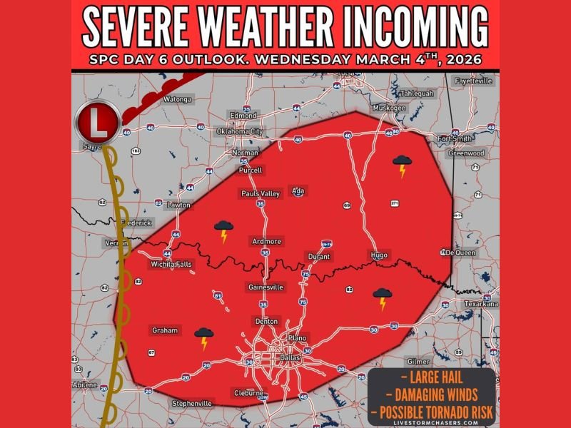
The early outlook signals that large hail and damaging winds are the primary threats, though forecasters note that a tornado risk cannot be ruled out as the system develops across the region.
Day 6 Outlook Targets Southern Oklahoma and North Texas
The highlighted risk area spans a broad section of southern Oklahoma and north-central Texas, covering several major population centers and transportation corridors.
In Oklahoma, the risk zone includes communities such as:
- Norman
- Purcell
- Pauls Valley
- Ada
- Ardmore
- Durant
- Hugo
In Texas, the outlined area extends across:
- Wichita Falls
- Gainesville
- Denton
- Dallas
- Plano
- Cleburne
- Graham
The risk zone also approaches areas near Fort Smith, Arkansas, and stretches westward toward parts of western Oklahoma.
The placement of the Day 6 risk indicates growing confidence that atmospheric conditions may support organized thunderstorm development, especially as a slow-moving system interacts with warmer, moisture-rich air returning from the Gulf.
Main Threats: Hail, Damaging Winds and Possible Tornadoes
The forecast highlights three primary concerns:
- Large hail
- Damaging straight-line winds
- Possible tornado development
While long-range outlooks often evolve as new data becomes available, early signals suggest sufficient instability and wind shear could combine to support strong to severe storms. The mention of tornado potential at this lead time suggests forecasters are monitoring ingredients that could favor rotating storms.
Given the broad geographic coverage of the risk area, impacts could vary significantly from one city to another. Urban centers such as Dallas and Plano could see strong thunderstorms if the system holds together, while communities like Ardmore, Ada, and Durant sit closer to the core of the highlighted zone.
Slow-Moving System May Signal Active March Pattern
The approaching storm system is described as slow-moving, which can sometimes enhance rainfall totals and prolong severe weather threats in affected areas. Early March often marks the beginning of a more active severe weather season across the Southern Plains.
This setup could signal the start of a more active severe weather pattern heading deeper into spring. Historically, Oklahoma and Texas frequently experience early-season severe outbreaks as Gulf moisture increases and upper-level systems move across the region.
At this stage, the Day 6 outlook serves as an early alert rather than a finalized forecast. Risk categories may be adjusted in the coming days as meteorologists refine timing, storm intensity, and precise impact zones.
Residents across southern Oklahoma and north Texas are encouraged to review severe weather safety plans, ensure weather alerts are enabled on mobile devices, and monitor forecast updates as Wednesday approaches.
For continued updates on regional severe weather developments and evolving forecasts, visit NapervilleLocal.com for in-depth coverage and tracking reports.

I’ve lived in Naperville long enough to see how quickly our community changes — from new developments downtown to sudden shifts in our Midwest weather. Reporting on Naperville news and daily forecasts gives me the chance to keep neighbors informed about what really matters. My goal is simple: deliver clear, timely updates so you always know what’s happening in our city and what to expect from the skies above.