
Oklahoma Braces for Rapid Temperature Crash and Wintry Mix Sunday Evening as Arctic Air Surges Into the State
OKLAHOMA — Meteorologists are warning Oklahoma residents to prepare for a dramatic temperature swing this weekend as record warmth on Saturday is expected to be followed by a rapid Arctic air plunge on Sunday evening, bringing the potential for sleet, freezing drizzle, and slick road conditions across parts of the state.
From Record Warmth to Arctic Cold in 24 Hours
Forecast models show Oklahoma may approach or even break all-time December temperature records on Saturday. However, the warm spell will be short-lived. By late Sunday, a surge of Arctic air will drop temperatures swiftly and sharply across central and eastern Oklahoma.
Meteorologists say the shift could occur within a matter of hours, catching many residents off guard if they are not aware of the incoming front.
Cities including Oklahoma City, Tulsa, McAlester, and surrounding areas will experience the most noticeable drop, with temperatures expected to fall quickly Sunday afternoon into the evening.
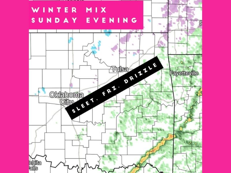
Freezing Drizzle, Sleet, and Light Snow Possible Sunday Evening
As the cold air deepens, areas along and northeast of Oklahoma City—including Tulsa and into northeastern counties—may see a wintry mix late Sunday. The primary threats include:
- Freezing drizzle
- Sleet
- A few isolated snowflakes
- Slick spots developing on untreated roads
Forecasters stress that even trace amounts of freezing drizzle can cause dangerous travel conditions, especially on bridges and elevated surfaces.
The wintry precipitation is expected to be light and patchy, but the combination of sudden temperature drops and freezing moisture could still create hazardous conditions for evening commuters.
Drivers Warned to Be Cautious as Slick Spots Develop
While widespread ice accumulation is not currently expected, officials caution that any freezing drizzle could lead to quick, hard-to-see icy patches, particularly after sunset. Road crews may need to treat priority routes, depending on how quickly temperatures fall.
Residents are encouraged to monitor local forecasts, especially those traveling Sunday night or early Monday morning. The MCWX Weather app and regional updates will provide live tracking as the Arctic air arrives.
A Classic Oklahoma Weather Whiplash
Oklahoma’s rapid, dramatic weather shifts are nothing new, but this weekend’s swing—from potential record highs to winter precipitation in roughly 24 hours—stands out even by state standards.
Meteorologists note that winter systems following periods of unusual warmth often produce freezing drizzle rather than heavy snow because the ground and mid-levels remain warm initially while Arctic air rushes in at the surface.
That combination creates one of the more challenging precipitation types to forecast—and the most subtle but dangerous for travel. Residents are urged to keep winter gear ready, prepare for rapidly changing conditions, and stay alert for additional updates as the situation develops.
For continuing coverage of Oklahoma’s winter weather, Arctic outbreaks, and regional forecasts, follow NapervilleLocal.com for the latest updates.

I’ve lived in Naperville long enough to see how quickly our community changes — from new developments downtown to sudden shifts in our Midwest weather. Reporting on Naperville news and daily forecasts gives me the chance to keep neighbors informed about what really matters. My goal is simple: deliver clear, timely updates so you always know what’s happening in our city and what to expect from the skies above.