
Oklahoma Drivers Warned of Freezing Drizzle and Sleet Thursday Morning, Creating Slick Spots for Early Commute
OKLAHOMA CITY, OKLAHOMA — A wintry mix of freezing drizzle and sleet is expected to develop early Thursday morning across much of central and northeastern Oklahoma, potentially causing slick road conditions during the morning commute, according to weather forecasters.
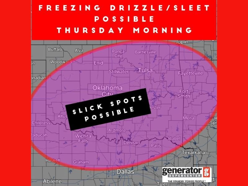
Meteorologists are closely monitoring this system, which could bring patchy light precipitation between pre-dawn hours and mid-morning, particularly along and north of Interstate 40. The affected area includes Oklahoma City, Tulsa, Stillwater, Enid, and Ardmore, with travel impacts most likely before 10 a.m.
Light Precipitation, Big Impact
While significant ice accumulation is not expected, even a light glaze from freezing drizzle or sleet can make roads and bridges extremely slippery — especially untreated surfaces.
Weather models show temperatures hovering near or just below freezing across the region at sunrise, increasing the risk of slick spots on elevated surfaces, overpasses, and secondary roads.
“Even minor icing can create hazardous travel,” forecasters cautioned. “The greatest concern is for the morning commute when temperatures will still be below freezing in many areas.”
The latest forecast, provided by Generator Supercenter of Tulsa, highlights a broad zone of concern stretching from Wichita Falls and Ardmore up through Oklahoma City, Tulsa, and Fayetteville, Arkansas.
Morning Commute Could Be Affected
Drivers heading to work early Thursday are advised to slow down, leave extra time for travel, and stay alert for icy patches. Road crews across Oklahoma are preparing to pre-treat bridges and highways ahead of the event, though conditions may still vary widely across counties.
Forecasters emphasize that the system is fast-moving, and precipitation should taper off by mid-to-late morning as temperatures gradually climb above freezing. However, areas north of Tulsa and into northeast Oklahoma could see lingering light sleet into the late morning hours.
Looking Ahead
After the brief wintry event, temperatures are expected to rebound slightly Thursday afternoon, with highs in the mid-40s and partly cloudy skies returning by evening.
Another cold front is expected early next week, though forecasters say it’s too early to determine whether additional winter precipitation will follow.
Residents across Oklahoma are encouraged to stay updated on the latest forecasts and use caution on the roads Thursday morning.
Stay informed on developing winter weather conditions at NapervilleLocal.com.

I’ve lived in Naperville long enough to see how quickly our community changes — from new developments downtown to sudden shifts in our Midwest weather. Reporting on Naperville news and daily forecasts gives me the chance to keep neighbors informed about what really matters. My goal is simple: deliver clear, timely updates so you always know what’s happening in our city and what to expect from the skies above.