
Oklahoma Faces Five Days of Severe Weather Hell: Baseball-Size Hail, Tornadoes, and Multiple Storm Rounds Threaten the State From Monday Through Friday
OKLAHOMA CITY, Okla. — Severe weather is roaring back into Oklahoma’s forecast in a major and prolonged way, with multiple rounds of dangerous storms threatening the state across five separate days — Monday, Tuesday, Tuesday night, Wednesday, and Friday.
This is not a single-event severe weather outbreak but rather a relentless multi-day siege that will keep Oklahoma residents on high alert through much of the week. Tuesday stands out as the most dangerous day, with numerous severe storms, all hazard modes in play, and hail potentially reaching baseball size.
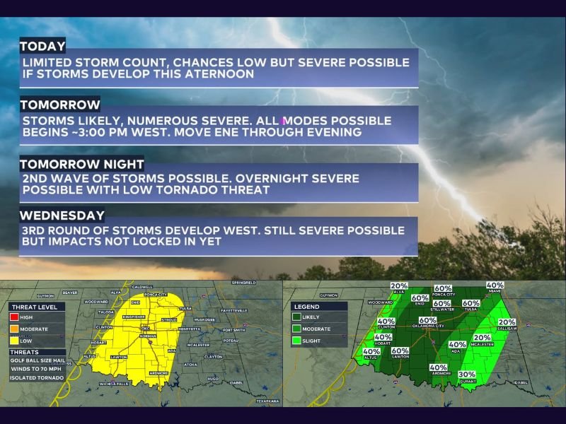
Today — Limited Storms But Severe Possible This Afternoon
Monday’s threat is the most limited of the week, with a 20% storm chance for any given area and a relatively low overall storm count expected. However, severe weather cannot be ruled out from storms that do develop this afternoon, with quarter to golf ball size hail possible alongside a very low but non-zero tornado risk.
The metro area storm threat zone covers western and central Oklahoma through roughly 6 to 10 PM, with the chance of rain and storms running between 40 and 60% across Oklahoma City, Stillwater, Tulsa, and Ponca City during the afternoon and evening hours.
Tuesday — The Most Dangerous Day. All Modes in Play
Tuesday is the day Oklahoma residents need to take most seriously this week. Numerous severe storms are likely, beginning along the dryline out west as early as 3 PM before moving east-northeast through the evening hours. The metro area faces its highest storm threat between 6 and 10 PM.
Every severe weather mode is on the table for Tuesday — large hail potentially reaching tennis to baseball size, damaging wind gusts, and an increased tornado threat compared to Monday. Storm coverage will be significantly more widespread than today, and multiple storms could be impacting different parts of the state simultaneously during the peak evening window.
Rain and storm chances across central Oklahoma run at 60% for Oklahoma City, Stillwater, Lawton, and Ponca City on Tuesday, with the tornado risk zone highlighted in red covering a broad swath from Enid and Ponca City through Oklahoma City and Stillwater into Tulsa and eastward.
Tuesday Night — Second Wave Brings Overnight Severe Risk
The severe weather threat does not end when Tuesday’s sun goes down. A second wave of storms is possible overnight into early Wednesday morning, carrying its own severe weather potential and a low but notable tornado threat through the overnight hours.
Residents should not assume the threat is over after the evening storms pass and should keep weather alerts active through the night. The overnight tornado risk zone shown in yellow covers a wide portion of western and central Oklahoma from midnight through 10 PM the following day.
Wednesday — Third Round Develops Out West
A third round of storm activity is forecast to develop across western Oklahoma on Wednesday afternoon and evening. While the atmosphere may be somewhat worked over from the previous two days of active weather — which could limit storm intensity — severe weather remains possible and impacts are not yet locked in.
Forecasters will fine-tune the Wednesday threat as the earlier storm rounds play out and a clearer picture of atmospheric conditions emerges going into midweek.
Friday — More Storms on the Way
As if five days of severe weather were not enough, yet another round of storm chances is on the radar for Friday. Details remain limited at this range, but residents should be aware that the active pattern is not expected to fully clear until late in the week at the earliest.
Oklahomans are urged to have their severe weather safety kit ready and accessible, download a reliable weather alert app, and know their shelter plan before storms arrive each day this week. Stay with NapervilleLocal.com for the latest weather updates and local forecast coverage.

I’ve lived in Naperville long enough to see how quickly our community changes — from new developments downtown to sudden shifts in our Midwest weather. Reporting on Naperville news and daily forecasts gives me the chance to keep neighbors informed about what really matters. My goal is simple: deliver clear, timely updates so you always know what’s happening in our city and what to expect from the skies above.