
Oklahoma, Kansas and Missouri Face Friday Severe Weather Threat With Large Hail, Damaging Winds and Isolated Tornado Risk
OKLAHOMA, KANSAS AND MISSOURI — The Storm Prediction Center has outlined portions of the Southern Plains and Mid-South in a Day 6 severe weather risk area for Friday, signaling increasing confidence that organized thunderstorms could develop late this week. While the event is still several days away, early projections suggest the potential for large hail, damaging winds, and isolated tornadoes across a multi-state corridor.
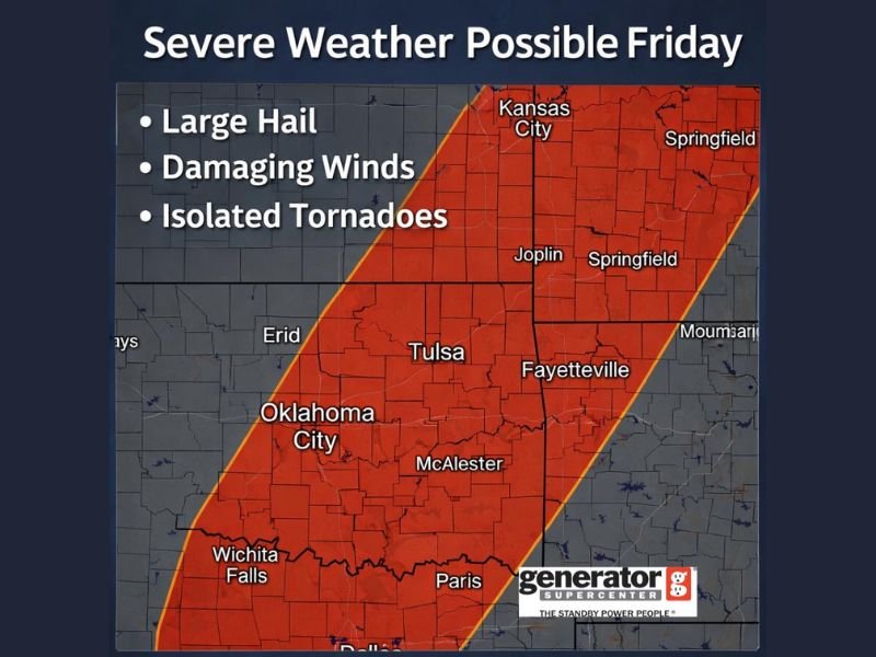
The highlighted risk zone stretches from north Texas through central and eastern Oklahoma, including Oklahoma City, Tulsa, McAlester, and Wichita Falls, and extends northeast into Kansas City, Joplin, Springfield, and Fayetteville. This broad corridor reflects a developing setup that may support strong storm organization as atmospheric conditions evolve.
Storm Prediction Center Signals Growing Confidence
Forecasters note that placement within a Day 6 outlook means the environment is beginning to show ingredients favorable for severe storm development. Although specific timing and storm mode details will continue to shift in the coming days, confidence is increasing that the region could see organized thunderstorms rather than isolated, weak activity.
The early risk area highlights a classic severe weather corridor from north Texas into Oklahoma and up toward western Missouri and southeastern Kansas. Cities including Tulsa and Oklahoma City sit near the center of the outlined threat zone, placing large population centers within potential impact areas if storms organize as projected.
Because the system is still days away, forecasters emphasize that exact impacts may change. However, identifying a broad risk region this far out often signals that meteorological ingredients such as instability, wind shear, and moisture return are aligning.
Primary Threats: Hail, Damaging Winds and Tornado Potential
The developing environment may support large hail capable of causing property damage, along with strong straight-line winds that could bring down trees and power lines. These two hazards are expected to be the primary concerns.
In addition, forecasters mention the possibility of isolated tornadoes, particularly if discrete supercell storms form within the broader storm complex. While widespread tornado activity is not currently indicated, even isolated tornadoes can produce significant localized impacts.
The threat area includes major transportation corridors and densely populated cities such as Kansas City and Springfield, increasing the importance of early preparedness. Storm details—including whether activity forms as a broken line or rotating individual cells—will play a critical role in determining overall severity.
Still Days Away, But Preparation Is Advised
Because this event remains several days out, officials stress that timing, storm mode, and exact impact zones may change. Forecast models will refine placement and intensity as Friday approaches.
Residents across the highlighted region are encouraged to review severe weather safety plans now rather than waiting for watches or warnings to be issued. Ensuring access to reliable weather alerts, identifying shelter locations, and staying informed as forecast updates are released will be important steps in the coming days.
The Day 6 designation does not guarantee widespread severe weather, but it does indicate that atmospheric signals are strong enough to warrant close monitoring. As confidence increases, more detailed outlooks and potential upgrades could follow.
For continued coverage of significant weather developments and regional updates, visit NapervilleLocal.com for timely reports and preparedness guidance.

I’ve lived in Naperville long enough to see how quickly our community changes — from new developments downtown to sudden shifts in our Midwest weather. Reporting on Naperville news and daily forecasts gives me the chance to keep neighbors informed about what really matters. My goal is simple: deliver clear, timely updates so you always know what’s happening in our city and what to expect from the skies above.