
Oklahoma, Kansas, Missouri, Arkansas, Texas Face Returning Storm Threat Tuesday Evening as Spring Pattern Turns Active
UNITED STATES — A more active spring weather pattern is beginning to take shape across the central United States, with storm chances expected to return as early as Tuesday evening across parts of Oklahoma and surrounding states.
Forecast guidance indicates that this shift could mark the start of a multi-day stretch of unsettled weather, with repeated rounds of showers and thunderstorms possible through late week and into the weekend.
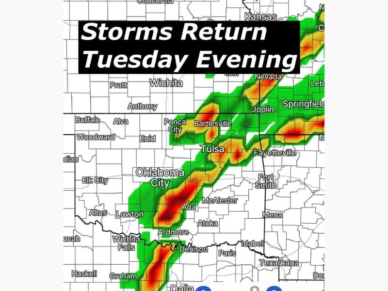
Storms Expected to Develop Tuesday Evening Across Oklahoma Region
Weather data shows a developing line of storms forming Tuesday evening, stretching from north Texas through southern and central Oklahoma into southeastern Kansas and southwestern Missouri.
Key cities in the potential storm corridor include:
- Dallas–Fort Worth, Texas
- Ardmore, Ada, and Oklahoma City, Oklahoma
- Tulsa and Bartlesville, Oklahoma
- Joplin, Missouri
- Fayetteville, Arkansas
This initial round of storms is expected to develop as moisture surges northward from the Gulf, interacting with an approaching system from the west.
Moisture Surge and Spring Setup Driving Storm Chances
Meteorologists point to a strengthening southerly flow that will transport warm, moist air into the Plains. At the same time, a developing trough over the western U.S. will help trigger lift across the region. This combination is a classic early spring setup that often leads to repeated storm development.
Severe Risk Still Uncertain but Increasing
At this stage, forecasters note that confidence remains limited on the exact severity of the storms. However, there is growing indication that at least some storms could become strong.
Potential impacts include:
- Gusty winds
- Small hail
- Frequent lightning
- Periods of heavy rainfall
While widespread severe weather is not yet guaranteed, the pattern suggests that stronger storms could develop as the week progresses.
Storm Chances Could Continue Through the Week
Beyond Tuesday, the pattern is expected to remain active, with additional rounds of storms possible across:
- Oklahoma
- Kansas
- Missouri
- Arkansas
- Texas
This extended setup means multiple opportunities for rainfall and thunderstorms, rather than a single event.
What This Means Going Forward
Residents across the central Plains and nearby regions should prepare for a more unsettled stretch of weather heading into early April.
- Tuesday evening marks the likely start of storm activity
- Conditions may support multiple rounds of storms
- Forecast details on timing and severity will become clearer in the coming days
This evolving pattern signals the transition into a more typical spring storm season across the central U.S. Stay with NapervilleLocal.com for continued updates as forecasters refine the storm outlook and track potential severe weather threats in the days ahead.

I’ve lived in Naperville long enough to see how quickly our community changes — from new developments downtown to sudden shifts in our Midwest weather. Reporting on Naperville news and daily forecasts gives me the chance to keep neighbors informed about what really matters. My goal is simple: deliver clear, timely updates so you always know what’s happening in our city and what to expect from the skies above.