
Oklahoma, Texas, and Arkansas Enter Heightened Snow Watch Window as Ensemble Models Signal Increasing Late-January Winter Potential
OKLAHOMA, TEXAS, AND ARKANSAS — Meteorologists are closely monitoring a developing ensemble snow signal that suggests a growing chance for measurable snowfall around January 25, based on AI-assisted ensemble guidance. While this is not a snowfall forecast, the presence of a long, continuous probability band across multiple states indicates that winter weather is becoming increasingly plausible as model agreement improves.
Forecasters emphasize that this stage of guidance is about trend recognition, not final impacts, but the signal is strong enough that the region should be paying close attention over the coming days.
What the Ensemble Snow Signal Represents
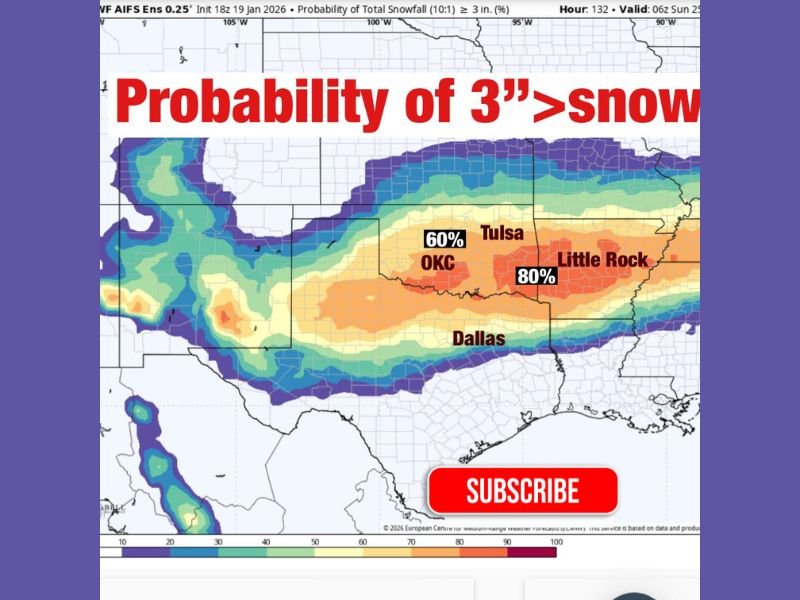
This data reflects the percentage of ensemble model members producing at least 3 inches of snow, not a deterministic forecast. Areas shaded with higher probabilities indicate greater agreement among model solutions, which is often the first step toward a more defined winter weather setup.
Importantly, this does not guarantee snow at any specific location, but it highlights where the atmosphere is increasingly supportive of a winter event.
Why Meteorologists Are Taking This Signal Seriously
When forecasters see a long, continuous band of elevated probabilities, it usually means several key things are happening behind the scenes:
Multiple storm solutions are beginning to align, the storm track window is becoming better defined, and confidence is increasing that some form of winter weather may occur.
In this case, ensemble probabilities are showing notable values across parts of Oklahoma, North Texas, and Arkansas, including around 60 percent near Oklahoma City and higher probabilities closer to central Arkansas, suggesting that confidence is trending upward regionally, even if placement still shifts.
What Could Still Change Before the Event
Despite the strengthening signal, uncertainty remains high at this range. Exact placement will almost certainly shift, and even small changes in storm track or temperature profiles could significantly alter outcomes.
Additionally, this guidance does not specify precipitation type, meaning rain, snow, or a mix are all still on the table depending on how cold air interacts with the system as timing approaches. Forecasters stress that details will not solidify until closer to the event, typically within a 72- to 48-hour window.
The Bottom Line for Late January
This is an early alert, not a final call, but it is strong enough that residents across Oklahoma, Texas, and Arkansas should begin factoring potential winter weather into late-January planning.
Confidence is increasing that something winter-related is possible, even though who gets snow and how much remains uncertain. Updates in the coming days will focus on narrowing down impacts, precipitation type, and travel concerns. For continued winter weather monitoring, forecast breakdowns, and regional trend updates, stay informed with ongoing coverage at NapervilleLocal.com.

I’ve lived in Naperville long enough to see how quickly our community changes — from new developments downtown to sudden shifts in our Midwest weather. Reporting on Naperville news and daily forecasts gives me the chance to keep neighbors informed about what really matters. My goal is simple: deliver clear, timely updates so you always know what’s happening in our city and what to expect from the skies above.