
Oklahoma–Texas Arctic Blast to Deliver Dangerous Wind Chills as Low as 1°F on Sunday Morning
OKLAHOMA — A powerful arctic blast will sweep across Oklahoma and North Texas early Sunday morning, driving wind chills close to 1°F in Tulsa, Enid, and Oklahoma City. The surge of frozen air will make conditions feel miserably cold, with several regions experiencing the harshest wind chills of the season so far.
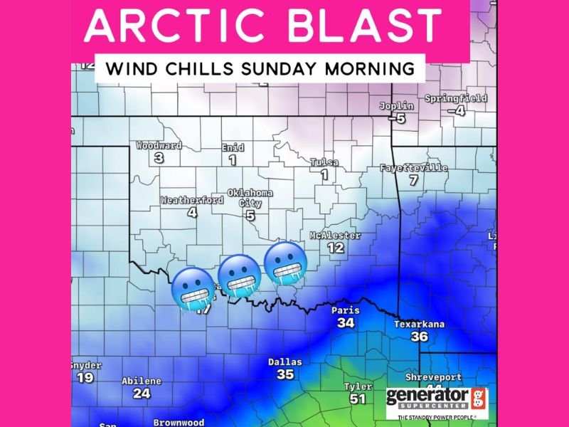
Wind Chill Map Shows Extreme Cold Across Oklahoma
Forecast data shows wind chills dropping to 1°F in Tulsa, 1°F in Enid, and 5°F in Oklahoma City, marking some of the coldest conditions seen this winter. Areas west of the metro, including Weatherford, are expected to feel wind chills around 4°F, while northern towns like Woodward will also sit near 3°F.
The cold intensifies farther east, with McAlester projected to feel like 12°F, and communities stretching into Missouri and Arkansas expected to bottom out between –4°F and –5°F. These values highlight the strength of the incoming arctic air mass and the rapid temperature plunge that will impact nearly the entire state.
Meanwhile, the southern edge of the cold zone reaches into North Texas, with Dallas expected to feel like 35°F and Texarkana near 36°F, signaling a sharp contrast between brutally cold northern counties and the more moderate but still chilly southern regions.
How This Arctic Blast Will Impact Residents
With such low wind chills, exposed skin may become vulnerable quickly, and outdoor activities early Sunday morning will feel significantly colder than actual air temperatures. Biting winds will add an extra layer of discomfort, making even short trips outside unpleasant.
Travelers should be aware that wind chill values near zero can cause stress on vehicles, outdoor machinery, and emergency generators. The map itself is branded by the Generator Supercenter of Tulsa, emphasizing how critical backup power can be during extreme winter weather. Residents who rely on generators should inspect fuel levels, ventilation, and connections before Sunday’s cold settles in.
Pets, livestock, and individuals working outdoors will be most at risk. Even though the event may be brief, the combination of freezing temperatures and strong wind gusts can lead to hypothermia if proper protection is not used.
Cold Conditions Could Offer Clues for Upcoming Winter Patterns
This strong arctic blast is another early sign that winter weather across the southern and central United States may trend colder than average. When arctic fronts push this deep into Oklahoma and Texas, it often reflects a broader pattern of high-latitude blocking, which can allow cold air to spill southward multiple times throughout December and January.
If similar patterns persist, residents from Oklahoma City to Dallas may face additional rounds of freezing temperatures and lower-than-normal wind chills in the coming weeks.
As this harsh cold sets in across several states, stay connected to NapervilleLocal.com for updates, safety tips, and continuing coverage of winter weather developments impacting communities nationwide.

I’ve lived in Naperville long enough to see how quickly our community changes — from new developments downtown to sudden shifts in our Midwest weather. Reporting on Naperville news and daily forecasts gives me the chance to keep neighbors informed about what really matters. My goal is simple: deliver clear, timely updates so you always know what’s happening in our city and what to expect from the skies above.