
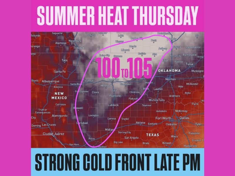
Oklahoma, Texas, New Mexico, Colorado and Kansas Brace for 100 to 105 Degree Heat Thursday Before Strong Late-Day Cold Front Arrives
WESTERN OKLAHOMA — A surge of intense summer-like heat is set to build across parts of the southern and central Plains on Thursday, sending temperatures soaring to levels more typical of late June than late March. The hottest zone is expected to stretch from western Oklahoma and west Texas into eastern New Mexico, southeast Colorado, and southwest Kansas, where many communities could reach or exceed the 100-degree mark before conditions begin changing later in the day.
This is not just a warm afternoon. The forecast points to a concentrated pocket of dangerous heat, with the core of the hottest air pushing into the 100 to 105 degree range across a broad multi-state corridor. That kind of heat this early in the season can catch people off guard, especially in areas where residents may not yet be fully prepared for summer-level temperatures.
Multi-State Heat Dome Builds Across the High Plains
The hottest part of Thursday’s forecast covers a wide stretch of the High Plains, including western Oklahoma, west Texas, eastern New Mexico, southeast Colorado, and southwest Kansas. Cities and towns within this zone are expected to feel the full force of the heat as afternoon temperatures rapidly climb under a very warm air mass.
The map shows the most intense heat centered from the Texas Panhandle and western Oklahoma back through eastern New Mexico and northward into parts of Colorado and Kansas. This creates a large, connected region where triple-digit temperatures are not just possible, but likely in many places.
Triple-Digit Temperatures Could Peak Between 100 and 105 Degrees
Forecast highs across the core heat zone are projected to land in the 100 to 105 degree range, making this one of the hottest weather setups seen so far this season. That kind of temperature is especially notable for late March, when many parts of this region are usually still transitioning through spring patterns rather than dealing with peak summer-style heat.
Even areas just outside the hottest core are likely to experience extreme warmth. Communities not reaching 100 degrees may still push deep into the 90s, which would still be unusually hot and potentially stressful for outdoor workers, travelers, and anyone spending extended time outside.
Heat Covers Western Oklahoma, West Texas and Nearby States
Western Oklahoma appears to be one of the key focal points in this setup, with nearby parts of west Texas also firmly inside the hottest air. Eastern New Mexico, especially areas east of the central mountains, is also in line for major heat, while southeast Colorado and southwest Kansas sit along the northern edge of the triple-digit zone.
That broad footprint matters because it means this is not an isolated hot spot. Instead, it is a regional heat event affecting several states at once, with a wide swath of communities facing similar conditions during the afternoon.
Strong Cold Front Expected Later Thursday
One of the most important parts of this forecast is that the heat will not remain in place indefinitely. A strong cold front is expected to move in later Thursday, bringing a sharp transition after the peak heating of the day. That creates a dramatic weather contrast, with extreme warmth ahead of the front and a much different air mass expected to arrive behind it.
This type of setup can make the day feel especially volatile, as people go from near-record or highly unusual heat to a much cooler pattern in a relatively short amount of time. The arrival of the front also raises attention because major air-mass clashes can often reshape the weather quickly across the Plains.
Why This Heat Event Stands Out
What makes this forecast especially noteworthy is both the intensity and the timing. Triple-digit heat across this region is remarkable enough on its own, but seeing values around 100 to 105 degrees in late March makes the event even more striking. It is the kind of setup that can feel shocking after cooler recent patterns and could create rapid changes in comfort and safety conditions during the day.
Residents across western Oklahoma, west Texas, eastern New Mexico, southeast Colorado, and southwest Kansas should be prepared for a very hot afternoon and stay alert for later forecast changes tied to the incoming front.
Stay with NapervilleLocal.com for more weather updates as this extreme Plains heat event and late-day cold front continue to develop.

I’ve lived in Naperville long enough to see how quickly our community changes — from new developments downtown to sudden shifts in our Midwest weather. Reporting on Naperville news and daily forecasts gives me the chance to keep neighbors informed about what really matters. My goal is simple: deliver clear, timely updates so you always know what’s happening in our city and what to expect from the skies above.