
Oklahoma Travel Advisory Issued as Freezing Drizzle, Sleet, and Snow Threaten Tulsa and Surrounding Counties Early Thursday
TULSA, OKLAHOMA — Winter weather conditions are set to create hazardous travel across portions of northeast and central Oklahoma, including the Tulsa metro area, as a mix of freezing drizzle, sleet, and light snow moves through early Thursday morning.
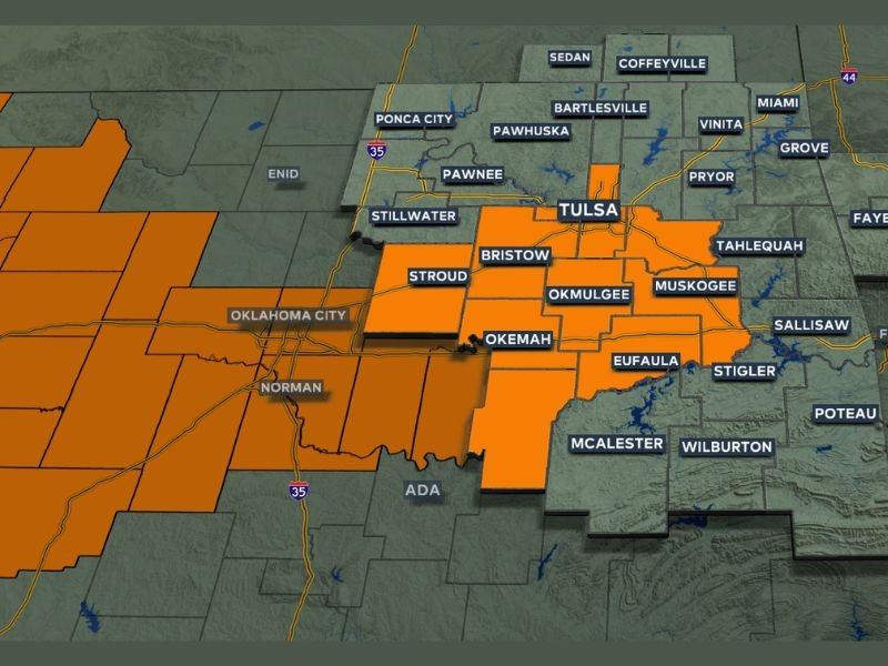
The National Weather Service and News On 6 Weather Team have issued a Travel Advisory beginning at 3 a.m. Thursday and lasting through at least 3 p.m.. The advisory warns drivers to expect slick roads, icy bridges, and reduced visibility during the morning commute, with conditions likely to worsen in untreated areas.
Freezing Drizzle and Sleet Could Create Early Morning Hazards
Forecasters say the system will begin producing light freezing drizzle overnight, eventually mixing with sleet and snow near the advisory zone by dawn. Although total accumulations are expected to remain light, even a small amount of ice can lead to dangerous driving conditions on highways and bridges.
“Temperatures will be hovering right around freezing, so even minor precipitation could quickly turn icy,” meteorologists explained. “The Thursday morning commute will likely be slick in spots, especially around Tulsa, Okmulgee, and Eufaula.”
Areas currently under the travel advisory include:
- Tulsa County
- Okmulgee County
- Muskogee County
- Bristow, Eufaula, and Henryetta areas
- Portions of Oklahoma City’s western suburbs
Additional counties could be added if the system expands or strengthens overnight.
Expected Impacts Across the Region
The main concerns through Thursday morning are:
- Icy roads and bridges, especially before sunrise
- Freezing drizzle and sleet, reducing traction on untreated surfaces
- Localized snow flurries possible near and north of Tulsa
- Potential delays on interstates and rural routes, including I-44 and Highway 75
Officials advise residents to limit travel during early hours, reduce speed, and leave extra space between vehicles. Pedestrians should also use caution on sidewalks and driveways, as black ice may not be visible until temperatures rise later in the day.
Slight Improvement by Thursday Afternoon
Temperatures are expected to climb just above freezing by late Thursday afternoon, helping melt some of the accumulated ice. However, shaded and elevated areas could remain slippery into the evening.
The advisory is expected to expire by 3 p.m. Thursday, though lingering slick spots may persist into the night as the next round of cold air moves into eastern Oklahoma.
Forecasters also note that additional winter weather systems could impact the region over the coming week as cold Arctic air continues interacting with moist southern flow patterns.
Residents are encouraged to stay updated on weather alerts and road conditions throughout the morning.
For continuous coverage and local winter weather updates, visit NapervilleLocal.com.

I’ve lived in Naperville long enough to see how quickly our community changes — from new developments downtown to sudden shifts in our Midwest weather. Reporting on Naperville news and daily forecasts gives me the chance to keep neighbors informed about what really matters. My goal is simple: deliver clear, timely updates so you always know what’s happening in our city and what to expect from the skies above.