
Oklahoma Under Thursday Morning Severe Weather Threat With Damaging Winds, Large Hail, and Brief Tornado Potential
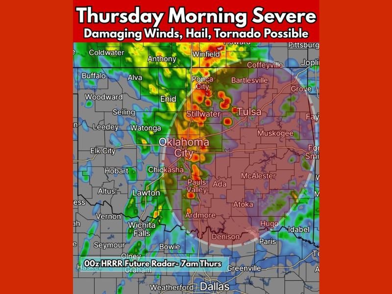
United States — New high-resolution model data shows central and eastern Oklahoma facing a Thursday morning severe weather threat, with conditions capable of producing damaging winds, large hail, and a low-end risk for brief tornadoes. The setup, highlighted in the latest HRRR forecast, indicates storms forming in southwest Oklahoma and tracking northeast across the state during early morning hours.
This early-day severe threat stands out due to its timing, as morning events can be more disruptive for commuters, schools, and early-shift workers.
What the Forecast Data Shows for Oklahoma
The map indicates a focused zone of storm development stretching from:
- Oklahoma City
- Stillwater
- Tulsa
- Ada
- McAlester
- Pauls Valley
- Ardmore
- Ponca City
Storms are expected to move from southwest to northeast, crossing the most populated corridor of the state during the morning travel period.
Model output highlights several potential hazards:
- Damaging wind gusts in the 50–70 mph range
- Hail up to the size of quarters
- Isolated rotating cells capable of producing a brief tornado
- Intense lightning and pockets of heavy rainfall
These signals point toward a localized but meaningful severe weather risk, especially along I-35 and into northeastern Oklahoma.
Why the Morning Timing Matters
Morning severe weather can be particularly dangerous due to:
- Lower situational awareness during commutes
- People asleep or not monitoring warnings
- Schools beginning morning arrival periods
- Limited daylight visibility during storm onset
Even a low-end tornado threat becomes more impactful when storms arrive before most people are prepared.
Storm Movement and Expected Progression
Meteorologists note that storms will likely develop in western or southwestern Oklahoma before sunrise, then organize into clusters as they travel northeast. This pattern often supports:
- Strong wind-driven segments
- Areas of embedded rotation
- Rapid intensification along boundary lines
Communities from Oklahoma City to Tulsa fall directly within the highlighted zone of concern.
Preparedness Considerations for Affected Regions
Residents in central and eastern Oklahoma should prepare for:
- Early-morning alerts and potential warning activations
- Hazardous driving conditions caused by wind, hail, and reduced visibility
- Securing loose outdoor items ahead of early morning hours
- Monitoring updates from local meteorologists and emergency agencies
Even a brief tornado or isolated damaging wind pocket can create localized damage during morning hours.
Looking Ahead
This severe weather risk is limited to Oklahoma based on the provided data and does not indicate broader impacts to the Midwest or Great Lakes. However, it represents a significant regional event worth monitoring as the next model runs refine storm placement and timing.
NapervilleLocal.com will continue to track national severe weather developments and provide accurate, responsible coverage as conditions evolve.

I’ve lived in Naperville long enough to see how quickly our community changes — from new developments downtown to sudden shifts in our Midwest weather. Reporting on Naperville news and daily forecasts gives me the chance to keep neighbors informed about what really matters. My goal is simple: deliver clear, timely updates so you always know what’s happening in our city and what to expect from the skies above.