
Oklahoma Weather Forecast Warns of Sleet and Snow Mix Thursday Afternoon, Creating Hazardous Road Conditions
OKLAHOMA CITY, OKLAHOMA — A new round of winter weather is expected to impact Oklahoma Thursday afternoon, bringing a mix of sleet and snow that could make for hazardous driving conditions during the evening commute, according to short-range weather models.
Meteorologists say no significant accumulations are projected at this time, but even light wintry precipitation could lead to slick roads and reduced visibility, especially in northern and central parts of the state.
Wintry Mix Developing Over Central and Northern Oklahoma
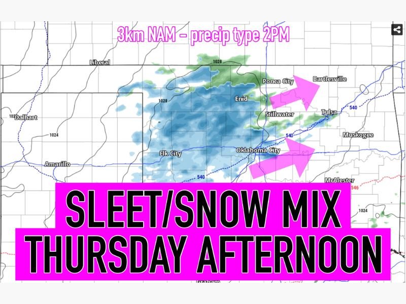
Forecasters using the 3km NAM model project that by 2 p.m. Thursday, a widespread area of sleet and light snow will develop and expand across Enid, Stillwater, Ponca City, and Oklahoma City, before pushing eastward toward Tulsa by late afternoon.
The National Weather Service has not yet issued any advisories, but experts warn that the timing of the storm coincides with rush-hour traffic, which could make roads treacherous despite limited accumulation.
“It’s not a major snowstorm, but it’s the type of system that can make travel messy very quickly,” one forecaster noted.
Temperatures are expected to hover just above freezing across much of the region, keeping most surfaces wet, though bridges and overpasses could see brief ice formation where sleet falls heavily.
Limited Accumulation, But Dangerous Travel Windows
While models currently indicate trace to light accumulation (under one inch), forecasters caution that the type of precipitation — sleet and wet snow — can still lead to short-term hazards, especially during heavier bursts.
Cities including Oklahoma City, Enid, and Tulsa should prepare for reduced visibility and slippery roadways during the afternoon and evening hours. The Oklahoma Department of Transportation (ODOT) has advised drivers to stay alert for changing road conditions and potential freezing spots overnight.
Residents in the affected areas should monitor updates from local meteorologists as forecast models continue to refine the storm’s strength and track.
Looking Ahead
Behind the system, colder air will continue to filter into Oklahoma Thursday night into Friday, with overnight lows dropping into the 20s for most of the region. The good news: skies will clear by Friday morning, ending the brief wintry episode.
However, this marks the first notable sleet and snow event of December for many Oklahomans — a reminder that winter travel hazards are beginning to return.
Motorists are urged to plan ahead, slow down, and use extra caution during the Thursday evening drive.
Stay tuned for continuous updates on Oklahoma’s winter weather outlook at NapervilleLocal.com.

I’ve lived in Naperville long enough to see how quickly our community changes — from new developments downtown to sudden shifts in our Midwest weather. Reporting on Naperville news and daily forecasts gives me the chance to keep neighbors informed about what really matters. My goal is simple: deliver clear, timely updates so you always know what’s happening in our city and what to expect from the skies above.