
Oregon and Washington Brace for Powerful Winds Thursday as Coastal Gusts Could Exceed 60 MPH
PORTLAND, OREGON — A powerful low-pressure system forming off the Oregon coast is forecast to bring strong winds and potentially hazardous conditions to much of western Oregon and parts of Washington on Thursday, meteorologists warn.
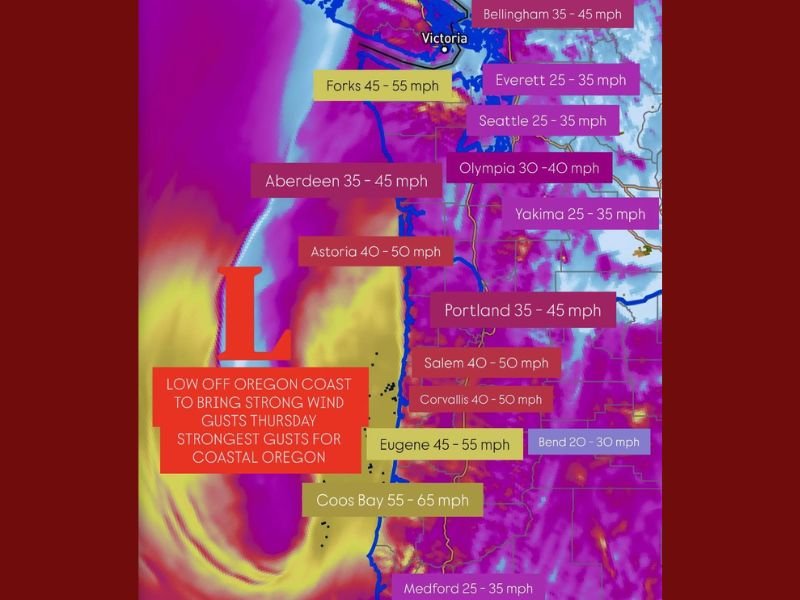
According to new high-resolution model guidance, the system will move closer to the Pacific Northwest coast, producing wind gusts between 40 and 60 mph across Oregon’s coastal areas and up to 65 mph near Coos Bay. Some interior valleys, including those near the I-5 corridor, could also experience gusts between 40 and 50 mph.
Strongest Winds Expected Along Coastal Oregon
Meteorologists say the most severe conditions are expected along Oregon’s coastline, where the storm’s center is projected to hover just offshore. The cities of Astoria, Salem, and Corvallis could see sustained gusts reaching 50 mph, while Eugene and Coos Bay may experience the most extreme winds, peaking near 55–65 mph.
“This setup has the potential to deliver the strongest coastal wind event so far this season,” weather analysts noted. “Areas along Highway 101 and near exposed beaches should prepare for gusty conditions that could lead to downed branches and brief power outages.”
While western Washington is expected to see some spillover impacts, including gusts between 25 and 45 mph, forecasters emphasize that Oregon remains the focal point of the storm’s intensity.
Localized Power Outages and Coastal Hazards Possible
Forecasters say the combination of strong wind gusts and saturated soil could lead to isolated power outages and minor property damage, particularly along the coast and in elevated areas.
Communities such as Portland, Astoria, and Eugene are being advised to secure loose outdoor items and prepare for possible disruptions. Utility crews are already on standby in anticipation of downed lines or fallen tree limbs.
“Even inland regions should be alert,” one forecaster said. “Gusts over 40 mph are strong enough to cause localized damage or knock out power for short periods.”
In addition to wind, rough surf and coastal flooding could become concerns for seaside towns. Mariners are urged to exercise caution, with gale warnings likely to be issued as the low-pressure system strengthens.
Winds Tapering by Late Thursday Night
The system is expected to peak in intensity Thursday afternoon into the evening, gradually weakening by early Friday as it moves northeast toward Canada. However, lingering breezes and cooler temperatures will persist across much of Oregon and western Washington into the weekend.
Forecast Wind Gust Ranges (Thursday):
- Coos Bay: 55–65 mph
- Eugene: 45–55 mph
- Salem / Corvallis: 40–50 mph
- Astoria: 40–50 mph
- Portland: 35–45 mph
- Aberdeen, WA: 35–45 mph
- Seattle / Everett: 25–35 mph
Residents Urged to Prepare
Officials recommend that residents check flashlights, charge electronic devices, and avoid unnecessary travel during the peak of the storm. For those along the coast, staying clear of beaches and jetty areas is strongly advised due to high surf and dangerous waves.
Naperville Local will continue to monitor and report updated weather alerts as the storm approaches the Pacific Northwest.

I’ve lived in Naperville long enough to see how quickly our community changes — from new developments downtown to sudden shifts in our Midwest weather. Reporting on Naperville news and daily forecasts gives me the chance to keep neighbors informed about what really matters. My goal is simple: deliver clear, timely updates so you always know what’s happening in our city and what to expect from the skies above.