
Pacific Northwest Weather Pattern Shifts as Blizzard Warnings, Flooding Concerns, and Several Feet of Mountain Snow Dominate the Forecast
WASHINGTON — After nearly two weeks of unusually warm 50-plus-degree December days, the Pacific Northwest is finally shifting into a colder winter pattern as the region deals with lingering impacts from Wednesday’s storm. The system brought blizzard conditions to the Cascades, widespread power outages, and damaging winds that reached 71 mph in Oak Harbor, 69 mph in Sequim, and over 50 mph in Seattle and Renton.
While the core of the recent storm has passed, authorities warn that flooding, additional mountain snow, and periodic wind surges will continue over the coming days as the storm track pushes farther south toward Oregon and California.
Flooding Concerns Remain but Begin to Improve
Western Washington will remain wet, but the shift in the main storm path means the region is entering the cooler side of incoming systems, allowing more moisture to fall as snow rather than rain. This transition helps reduce flood risk, especially with snow levels dropping to or below Snoqualmie Pass and staying there for the foreseeable future.
Hydrologists note that the “purple boxes” signaling major river flooding have disappeared from the forecast maps. Rivers such as the Skagit, Snohomish, and Snoqualmie—which were recently at moderate flood stage—are now receding and expected to remain within their normal boundaries.
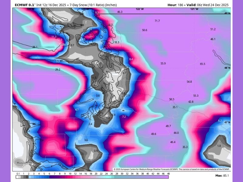
Mountain Snowfall Becoming the Major Story
With holiday travel beginning, forecasters say the next several days will be very challenging for mountain crossings, especially with Stevens Pass still experiencing extended closures. The Cascades are expecting a parade of snowstorms with multiple feet of accumulation, potentially 4–5+ feet by Christmas according to early projections.
This is welcome news for ski resorts and regional snowpack, which has been running below normal so far this season. However, it is not great news for drivers, especially those unaccustomed to winter mountain conditions.
Lowland Snow Chances Increasing as Pattern Cools
While lowland areas return to typical 40s and rain, the cooler west-northwest flow next week may push snow levels toward the fringe lowland elevations. Meteorologists estimate a 70–80% chance of daily precipitation through Christmas, with a small window for low-elevation snow around December 23.
A major lowland snow event is uncertain, but the long stretch of 50-degree days is over — and residents may soon be rooting for temperatures in the “3s and 2s” instead. For continued updates on national storm patterns and how winter systems may impact the Midwest, stay with NapervilleLocal.com.

I’ve lived in Naperville long enough to see how quickly our community changes — from new developments downtown to sudden shifts in our Midwest weather. Reporting on Naperville news and daily forecasts gives me the chance to keep neighbors informed about what really matters. My goal is simple: deliver clear, timely updates so you always know what’s happening in our city and what to expect from the skies above.