
Pennsylvania Braces for Powerful Cold Front, Lake-Effect Snow, and Dangerous Wind Gusts on Monday
PENNSYLVANIA — A strong cold front sweeping across the state Monday is setting the stage for a chaotic weather pattern, bringing rapidly falling temperatures, heavy lake-effect snow in the northwest, scattered snow squalls through central Pennsylvania, and widespread damaging wind gusts. Forecasters warn that travel conditions may deteriorate quickly, especially in the heaviest snow belts and along exposed roadways.
Temperatures Crash as Cold Front Crosses the State
Temperatures will drop sharply through the day as the cold front pushes east. Morning highs will be deceiving, with the warmest readings occurring before midday. By mid-to-late afternoon, western and central Pennsylvania will fall into the 20s, while eastern areas drop into the 30s.
Lingering morning rain showers across central and eastern counties will gradually transition to snow as colder air fills in. Heavier lake-effect snow showers are expected to become more organized through the afternoon, particularly downwind of Lake Erie.
Heavy Lake-Effect Snow and Snow Squalls in the Northwest
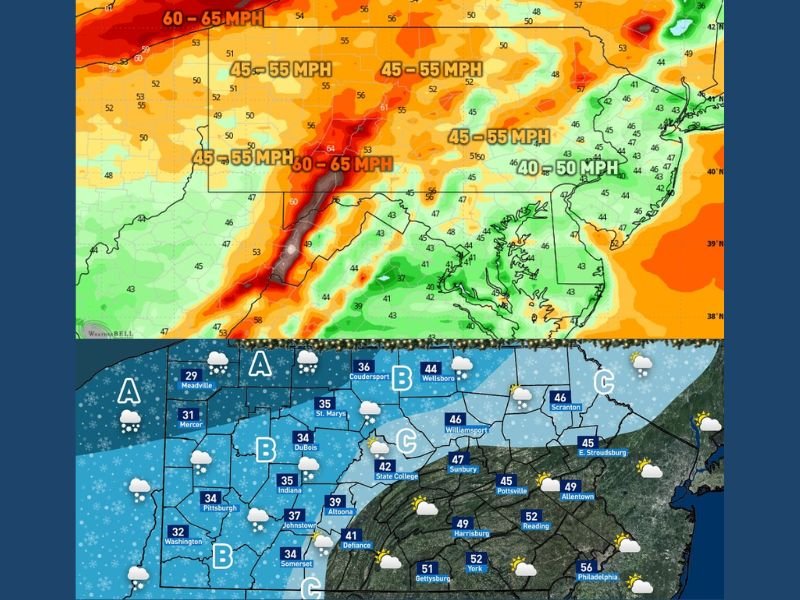
Forecasters highlight Area A—the far northwestern corridor including Erie, Meadville, and surrounding counties—as the primary zone for heavy lake-effect snow showers and intense snow squalls. Visibility may drop to near zero at times, creating sudden whiteout conditions and hazardous travel.
Road conditions in this corridor can change within minutes as lake-effect snow bands shift. Motorists are advised to exercise extreme caution, especially along Interstates 79 and 90.
Scattered Snow Squalls Expected Across Central Pennsylvania
In Area B, which includes Pittsburgh, DuBois, Indiana, and Johnstown, scattered lake-effect snow showers are expected to develop through the day. Brief bursts of heavy snow could create low visibility and slick spots as conditions deteriorate quickly during passing squalls. Temperatures falling below freezing will increase the risk of icy roadways, even where snowfall totals remain light.
Isolated Snow Showers for Eastern and South-Central Counties
Area C, covering regions such as State College, Williamsport, and parts of northeastern Pennsylvania, could see isolated snow showers by late afternoon and evening. While overall snow amounts are expected to stay light—generally coatings up to 1 inch—cold air arriving overnight may cause any untreated wet surfaces to freeze. These smaller snow events may not be as disruptive as in the northwest, but slippery travel remains possible.
Widespread Damaging Wind Gusts Expected
The cold front brings very strong winds statewide, with most of Pennsylvania forecast to experience gusts between 45–55 mph, and ridge-top areas potentially reaching 60–65 mph. These winds may cause scattered power outages, falling branches, and minor tree damage.
Loose outdoor items may blow across roads or yards, and forecasters encourage residents to secure trash cans, decorations, and patio items before winds peak.
Statewide Travel Hazards Through Monday Afternoon and Evening
Travelers should prepare for rapidly changing conditions, particularly in the north and west. Snow squalls, blowing snow, and strong crosswinds will create hazardous driving scenarios on exposed highways. Near-whiteout conditions are possible where squalls pass through quickly, while temperatures dropping below freezing could cause flash freeze conditions in some areas.
Pennsylvania residents are encouraged to stay updated on changing weather alerts and use caution if traveling during peak wind and snow activity. Stay connected with NapervilleLocal.com for continuing weather coverage and updates.

I’ve lived in Naperville long enough to see how quickly our community changes — from new developments downtown to sudden shifts in our Midwest weather. Reporting on Naperville news and daily forecasts gives me the chance to keep neighbors informed about what really matters. My goal is simple: deliver clear, timely updates so you always know what’s happening in our city and what to expect from the skies above.