
Pennsylvania Faces Its Most Significant Winter Storm Pattern in Decades as Northern Track Scenario Gains Strength This Weekend
PENNSYLVANIA — A rare and potentially historic winter storm pattern is taking shape across Pennsylvania this weekend, with meteorologists warning that the state may be on the doorstep of its most impactful winter storm setup in decades. Recent storm data collection has triggered a significant shift toward a stronger, more northerly storm track, dramatically increasing the risk of widespread winter weather impacts.
Fresh observations gathered overnight by NOAA Hurricane Hunter aircraft, sampling the Pacific portion of the storm system, have been fully ingested into forecast models, resulting in a more amplified and better-organized storm scenario.
Why This Storm Pattern Is Different From Past Winters
Forecasters note that this is the type of large-scale atmospheric pattern residents have been asking about for years when questioning why major snowstorms have been scarce.
This setup features:
- Deep amplification of the storm system
- A pronounced northward track shift
- Cold air firmly established across much of Pennsylvania
- A prolonged impact window from Saturday night through Monday afternoon
Meteorologists emphasize that this is not a fast-moving system, increasing the likelihood of heavy, long-duration snowfall across large portions of the state.
Breakdown of the Three Winter Storm Scenarios
Forecast guidance outlines three primary scenarios, each defining how impacts could unfold across Pennsylvania.
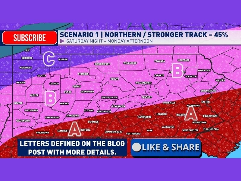
Scenario 1 — Northern and Stronger Track (Highest Probability at 45%)
This scenario places the storm on a more northerly and intensified path, bringing widespread heavy snow to much of Pennsylvania from Saturday night into Monday afternoon. This solution supports significant accumulation across central and northern portions of the state, with strong confidence in disruptive impacts.
Scenario 2 — Central Track (Moderate Probability)
A slightly farther south solution would still bring substantial snowfall, but with sharper gradients between heavier snow to the north and mixed precipitation farther south. Impacts remain high but more localized.
Scenario 3 — Southern Track (Lower Probability)
This outcome would confine the heaviest snow closer to southern Pennsylvania while reducing totals farther north. Even in this scenario, meaningful winter impacts would still occur, though less extreme.
Regional Impact Zones Highlighted Across the State
The scenario map divides Pennsylvania into impact zones labeled A, B, and C, each representing differing storm outcomes.
- Zone A (Southern Pennsylvania) may see warmer air intrusion, increasing the risk of mixed precipitation or reduced snowfall.
- Zone B (Central Pennsylvania) represents the core risk area, where heavy, sustained snowfall is most likely.
- Zone C (Northern Pennsylvania) remains firmly cold, supporting consistent snow throughout the event.
These zones underscore how small shifts in storm track could produce dramatically different outcomes over short distances.
Timing and Duration Increase the Risk of Major Disruption
One of the most concerning elements of this storm is its lengthy duration. Snow is expected to begin Saturday night, intensify through Sunday, and continue into Monday afternoon.
Extended snowfall increases risks of:
- Hazardous travel
- Snow-covered roadways for prolonged periods
- Strain on snow removal operations
- Potential infrastructure stress
Meteorologists stress that duration alone could elevate this event into high-impact territory, even if snowfall rates fluctuate.
Why Forecasters Are Closely Watching This Event
The combination of Hurricane Hunter data, model amplification, and a strong northern-track signal makes this storm one that demands close monitoring.
Forecasters describe the current setup as one of the most compelling winter storm signals seen in many years, especially given how consistently models have trended toward a stronger solution.
Confidence is growing that Pennsylvania will experience a major winter weather event, though final intensity and distribution will depend on subtle atmospheric details still resolving.
Residents across the state should prepare for significant winter impacts and continue monitoring forecast updates as the storm approaches. For continued in-depth winter weather analysis and clearly explained forecast updates, follow ongoing coverage from NapervilleLocal.com.

I’ve lived in Naperville long enough to see how quickly our community changes — from new developments downtown to sudden shifts in our Midwest weather. Reporting on Naperville news and daily forecasts gives me the chance to keep neighbors informed about what really matters. My goal is simple: deliver clear, timely updates so you always know what’s happening in our city and what to expect from the skies above.