
Pennsylvania, New York, New Jersey, Maryland, and Virginia Could See Christmas Eve Winter Storm as Models Indicate Potential East Coast System
EASTERN UNITED STATES — Early weather models are signaling the possibility of a developing winter storm along the East Coast around Christmas Eve, potentially bringing a mix of snow, sleet, and freezing rain to parts of Pennsylvania, New York, New Jersey, Maryland, and Virginia. However, forecasters emphasize that it’s still too early for certainty, as data remains in the long-range phase and could change substantially in the days ahead.
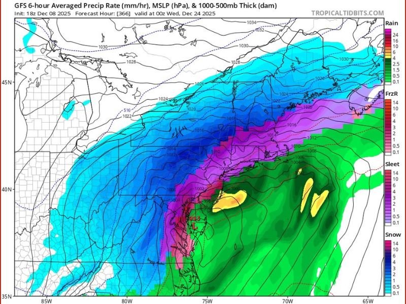
GFS Model Shows Possible Coastal Low Development
Recent runs of the Global Forecast System (GFS) suggest a low-pressure system forming off the Mid-Atlantic coast on December 24, spreading wintry precipitation northward into the Appalachians and Northeast. The current model indicates heavy snowfall potential across central Pennsylvania and upstate New York, while areas closer to the coast, including New Jersey, Delaware, and Maryland, could experience mixing or freezing rain due to warmer air intrusion from the Atlantic.
Experts caution, however, that this setup is not yet reliable. “At this range, the model has about as much support as a rubber crutch on an icy driveway,” one forecaster noted, adding that atmospheric alignment rather than exact storm position is what’s most important for now.
Atmospheric Signals Suggest Increased Holiday Activity
While the exact track and intensity remain uncertain, multiple forecasting indicators suggest that the atmosphere is trending toward more active conditions around Christmas week. Meteorologists say the jet stream configuration and energy patterns appear to be lining up for potential coastal development, which could lead to more significant winter weather if timing aligns correctly.
The latest Tropical Tidbits map shows broad zones of precipitation, with snow dominating the northern Mid-Atlantic and Northeast, while rain and sleet appear possible along southern sections near Richmond, Washington D.C., and coastal Virginia.
Holiday Travelers Urged to Stay Cautious
With Christmas Eve still over two weeks away, forecasters advise against making firm travel changes yet. Instead, residents across the Mid-Atlantic and Northeast should monitor local forecasts as higher-resolution models come into play next week.
As one meteorologist summarized, “The big picture says something could happen — we just don’t know the details yet.”
Stay tuned to NapervilleLocal.com for continued coverage and updates on this developing East Coast winter weather threat affecting Pennsylvania, New York, New Jersey, Maryland, and Virginia.

I’ve lived in Naperville long enough to see how quickly our community changes — from new developments downtown to sudden shifts in our Midwest weather. Reporting on Naperville news and daily forecasts gives me the chance to keep neighbors informed about what really matters. My goal is simple: deliver clear, timely updates so you always know what’s happening in our city and what to expect from the skies above.