
Pennsylvania Snow Forecast Downgraded as Weakening Midwest Shortwave Breaks System Apart, Cutting Totals to 1–2 Inches at Best
PENNSYLVANIA — A winter system that once showed more promise has significantly weakened overnight, leading forecasters to scale back snowfall expectations across the state as the disturbance moves eastward out of the Midwest.
Meteorologists say the primary driver behind the downgrade is a shortwave that lost strength while crossing the Midwest, resulting in a much less organized system by the time it reached Pennsylvania.
Why the Snow Potential Collapsed Overnight
Forecast guidance indicates the shortwave energy failed to maintain intensity upstream, which limited moisture and lift as the system entered the region. With weaker dynamics in place, snowfall coverage and intensity have dropped substantially. This breakdown means widespread accumulating snow is no longer expected, and most areas will see little more than nuisance-level precipitation.
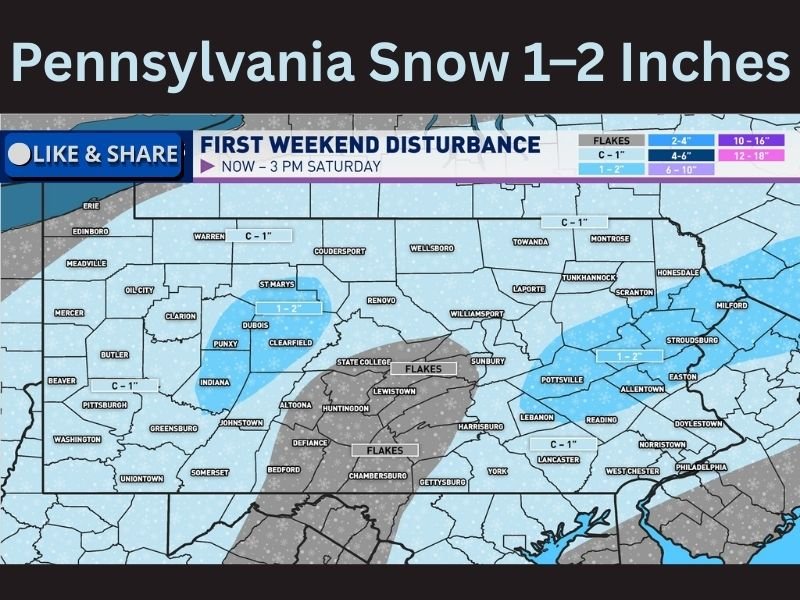
Where Snow Still Has a Chance to Accumulate
Despite the overall downgrade, parts of eastern Pennsylvania could still see localized accumulations of 1 to 2 inches, mainly in narrow bands where snowfall briefly becomes steadier. Much of central Pennsylvania is expected to see flurries or very light snow, with limited accumulation.
Temperatures Help Keep Roads in Better Shape
Surface temperatures hovering near the freezing mark will work against efficient accumulation on roadways. While grassy and elevated surfaces may briefly whiten, road conditions are expected to remain relatively manageable, especially outside of heavier bursts. This temperature profile significantly reduces the risk of widespread travel disruption.
Bottom Line
What once looked like a more impactful winter setup has largely fallen apart, leaving Pennsylvania with spotty light snow rather than a meaningful winter event. A few localized areas may still see minor accumulation, but overall impacts should remain limited. For continued winter weather updates, forecast changes, and regional pattern tracking, follow along with NapervilleLocal.com and stay weather-aware.

I’ve lived in Naperville long enough to see how quickly our community changes — from new developments downtown to sudden shifts in our Midwest weather. Reporting on Naperville news and daily forecasts gives me the chance to keep neighbors informed about what really matters. My goal is simple: deliver clear, timely updates so you always know what’s happening in our city and what to expect from the skies above.