
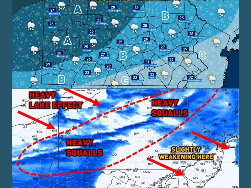
Pennsylvania Snow Squalls and Lake-Effect Snow Expected December 31, Creating Hazardous Travel Conditions Across Multiple Regions
Pennsylvania — An active winter weather pattern is expected to impact large portions of the state on Wednesday, December 31, as a combination of lake-effect snow and a passing weather disturbance brings snow showers, snow squalls, and rapidly deteriorating travel conditions, particularly from the afternoon into the overnight hours.
Forecasters indicate that conditions will worsen quickly once heavier snow bands develop, with brief whiteout visibility, sudden slick roads, and sharply reduced travel safety possible in multiple regions. While some areas may see lighter snow early in the day, the most significant impacts are expected later as the system strengthens and shifts eastward.
Lake-Effect Snow and Snow Squalls Drive the Main Threat
The primary concern Wednesday is the development of intense snow squalls tied to lake-effect snow bands, especially across western and northern Pennsylvania. These fast-moving squalls can produce near-zero visibility, heavy snowfall in short bursts, and dangerous driving conditions with little warning.
Snow squalls are particularly hazardous because they can instantly change road conditions, turning wet pavement into icy surfaces within minutes. Motorists may encounter sudden whiteouts along major corridors, especially during the late afternoon commute and evening hours.
Regional Breakdown: What to Expect by Area
Area A (Western and Northwestern Pennsylvania):
Light snow is possible during the morning hours, becoming more steady by early to mid-afternoon. By mid-to-late afternoon, heavier snow showers and snow squalls are expected to develop. These squalls may contain lake-effect enhancement, leading to brief but intense snowfall and rapidly worsening visibility.
Area B (Central and Northern Interior Regions):
Morning flurries or light snow will gradually increase through the afternoon. By evening and early overnight, snow squalls may become more widespread. Travel conditions could deteriorate quickly as lake-effect snow bands shift through the region, producing hazardous driving conditions.
Area C (Southeastern Pennsylvania):
Light snow or flurries are expected during the morning, tapering off by mid-morning. Conditions may briefly improve before another round of snow arrives during the evening and overnight hours. While snowfall intensity may be lower compared to western areas, snow squalls remain possible overnight, especially as colder air moves in.
Timing and Travel Impacts
The highest risk window for dangerous travel appears to be from late afternoon through midnight, when snow squalls are most likely to intensify. Even areas that see limited accumulation could experience rapid visibility drops, sudden braking hazards, and slick roadways.
Drivers are urged to remain alert, reduce speed during snow squalls, and avoid unnecessary travel during peak impact hours. Road conditions may change faster than standard winter forecasts suggest due to the localized and sudden nature of snow squalls.
Why This System Is Unusual
This event stands out because it combines lake-effect snow with a fast-moving disturbance, increasing the likelihood of short-duration but high-impact snow events rather than a steady, predictable snowfall. Such setups often lead to more accidents and travel disruptions despite lower overall snow totals.
What Residents and Travelers Should Do
Residents and travelers across Pennsylvania should monitor local weather updates closely, allow extra travel time, and be prepared for rapidly changing road conditions. Keeping emergency supplies in vehicles and staying informed about current conditions may help reduce risk during this active winter weather event.
For continued regional weather coverage and developing forecasts that may affect travel beyond Pennsylvania, visit NapervilleLocal.com for timely updates and detailed reports.

I’ve lived in Naperville long enough to see how quickly our community changes — from new developments downtown to sudden shifts in our Midwest weather. Reporting on Naperville news and daily forecasts gives me the chance to keep neighbors informed about what really matters. My goal is simple: deliver clear, timely updates so you always know what’s happening in our city and what to expect from the skies above.