
Pennsylvania Welcomes First Day of Spring With Widespread Rain, Thunder Risk and Up to Half-Inch Totals From Pittsburgh to Philadelphia
PENNSYLVANIA — The first official day of spring is arriving with a wet and active pattern across the state, as rain showers spread from northwest to southeast throughout the day, bringing steady precipitation and even a slight chance of thunder in some areas.
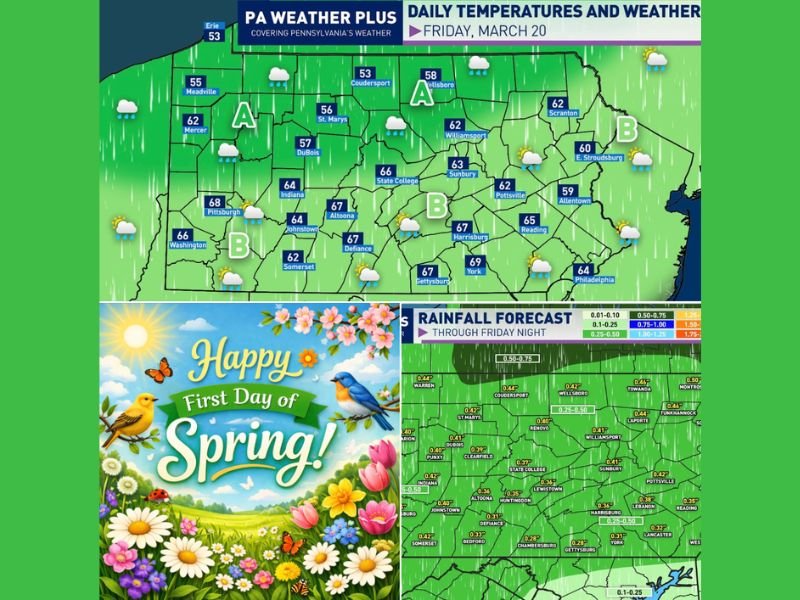
After a long winter, the seasonal transition is making itself known not with sunshine, but with widespread rainfall impacting cities from Pittsburgh to Philadelphia.
Rain Moves Across the State in Two Phases
Meteorologists are tracking a system moving across Pennsylvania in waves, dividing the state into two main impact zones:
Area A: Morning to Early Afternoon Rain
- Rain arriving mid-morning through early afternoon
- Heavier showers with embedded downpours possible
- Focused across northwestern and north-central Pennsylvania, including areas near Erie, DuBois, and State College
Area B: Afternoon to Evening Showers
- Rain spreading into central, southern, and eastern regions later in the day
- Showers arriving early to mid-afternoon, later in far southeastern areas
- A chance of isolated thunder, especially toward the southeast
Cities including Harrisburg, York, Allentown, and Philadelphia will see rain develop later compared to western parts of the state.
Rainfall Totals Could Reach Half an Inch
This system is expected to bring:
- 0.25 to 0.50 inches of rain statewide
- Locally higher amounts in areas with heavier downpours
- Steady, soaking rainfall rather than severe storms
While thunder is possible, forecasters emphasize that severe weather is not expected.
Temperatures Reflect a Classic Spring Setup
Daytime highs across Pennsylvania will vary depending on timing of the rain:
- Upper 50s to low 60s in northern areas
- Mid to upper 60s across central and southern regions
- Cooler conditions lingering where rain arrives earlier
Cities like Pittsburgh (upper 60s), Harrisburg (mid to upper 60s), and Philadelphia (mid-60s) will experience mild but damp conditions.
A Symbolic Start to Spring
Although not the sunny start many might hope for, this weather pattern is typical for early spring in Pennsylvania:
- Transition from winter to warmer conditions
- Increased storm systems moving through
- Gradual warming trend despite unsettled days
The rainfall will also help replenish soil moisture heading into the growing season.
Final Outlook
Pennsylvania’s first day of spring is shaping up to be wet, mild, and occasionally stormy, with rain spreading statewide and totals reaching up to half an inch.
From Pittsburgh to Philadelphia, residents should prepare for a soggy but seasonally appropriate start to spring, with improving conditions expected after the system moves out. Stay tuned to Naperville Local for more nationwide weather updates and major forecast shifts across the United States.

I’ve lived in Naperville long enough to see how quickly our community changes — from new developments downtown to sudden shifts in our Midwest weather. Reporting on Naperville news and daily forecasts gives me the chance to keep neighbors informed about what really matters. My goal is simple: deliver clear, timely updates so you always know what’s happening in our city and what to expect from the skies above.