
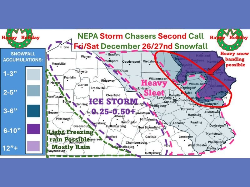
Pennsylvania Winter Storm Expected to Bring 6–10 Inches of Snow, Up to 0.50″ Ice, and Heavy Sleet December 26–27, Forecasters Warn
Pennsylvania — A major December 26–27 winter storm is expected to impact Pennsylvania with a mix of heavy snow, significant ice accumulation, and dangerous sleet, according to the latest “second call” forecast from regional meteorologists and NEPA Storm Chasers. Experts warn that travel should be avoided Friday into early Saturday due to hazardous and rapidly deteriorating road conditions.
Forecasters Warn of 6–10 Inches of Snow Where Changeover Does Not Occur
Meteorologists note that areas remaining all snow could receive 6–10 inches, with heavier totals possible in areas where strong snow bands set up across northeastern Pennsylvania. The heaviest snowfall potential has shifted slightly southward from previous forecasts, but the risk remains high for locations within the marked red-circled region on the map.
Forecasters emphasize that this storm has the potential to produce very heavy, wet snow, which is more difficult to plow and significantly more slippery than lighter snow. Because sleet has a 6:1 water ratio compared to snow’s typical 10:1, areas that see sleet instead of snow may receive less accumulation but more hazardous travel conditions.
Significant Ice Storm Threat: 0.25–0.50″+ Accretion Possible
The storm carries a substantial threat of freezing rain, particularly across central Pennsylvania and the higher elevations of southern PA. Forecast maps indicate an ice storm zone where 0.25″ to 0.50″ or more of ice may accumulate.
Meteorologists warn that this is not a warm-air advection storm where the surface is too warm. Instead, surface temperatures will be cold enough to support freezing rain even if upper-level temperatures rise slightly. This means precipitation will fall as ice or sleet, creating dangerous roadway conditions.
Key concerns include:
- Icy roads and black ice formation
- Difficult travel on hills and mountain passes
- Rapid deterioration of road conditions
- Risk of isolated power-line stress in heavy ice zones
Although widespread power outages are not guaranteed, forecasters caution that any location within the 0.50″ ice zone should prepare for potential disruptions.
Heavy Sleet and Snow Banding Expected Across Northeastern Pennsylvania
The second-call forecast highlights the potential for heavy sleet across regions including Williamsport, Lewisburg, and portions of the Susquehanna Valley. Sleet zones greatly reduce total snowfall but create high-impact driving hazards.
The northeastern portion of the state—including Scranton, Wilkes-Barre, Montrose, and Milford—is at risk for heavy snow banding, which could significantly increase totals if cold air holds.
Meteorologists stress that even a 1–2°F difference at 10,000 feet could determine whether an area receives 6–10 inches of snow or a mix of sleet and freezing rain. Because of this uncertainty, residents must remain alert to updated forecasts.
Residents Urged to Avoid Travel and Prepare for Hazardous Conditions
Weather officials strongly advise Pennsylvanians to stay home if possible, especially Friday afternoon through early Saturday. Roads may become extremely slippery or impassable where a snow–sleet–ice mix occurs.
Recommended precautions include:
- Completing errands before the storm arrives
- Charging devices and preparing emergency kits
- Avoiding all unnecessary travel
- Monitoring official weather updates Friday morning
Forecasters note that additional adjustments may be made early Friday morning as new data becomes available. For continuous storm tracking, travel updates, and official winter alerts, visit NapervilleLocal.com for reliable regional coverage.

I’ve lived in Naperville long enough to see how quickly our community changes — from new developments downtown to sudden shifts in our Midwest weather. Reporting on Naperville news and daily forecasts gives me the chance to keep neighbors informed about what really matters. My goal is simple: deliver clear, timely updates so you always know what’s happening in our city and what to expect from the skies above.