
Persistent Cold Signal Centers on Arkansas and Expands Across the Central and Eastern U.S. From February 6–10, With More Wintry Weather Possible
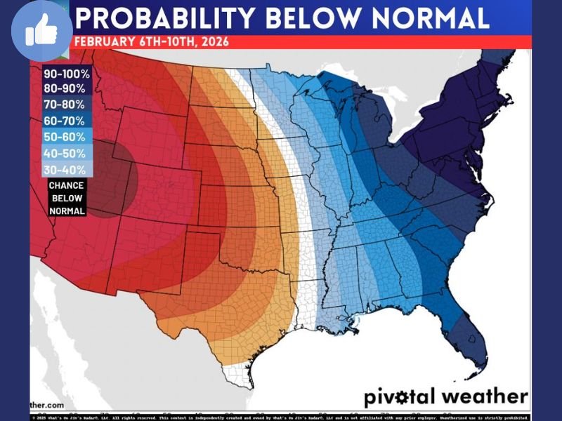
UNITED STATES — A new long-range temperature outlook shows a strong and persistent signal for below-normal temperatures centered on Arkansas, with cold conditions extending across large portions of the central and eastern United States during the February 6 through February 10 timeframe.
Forecast confidence is high enough that meteorologists are already flagging the pattern as one that could lock colder-than-average air in place, rather than allowing a quick warm-up.
Arkansas Sits Near the Core of the Cold Pattern
The probability map highlights Arkansas positioned near the heart of the colder-than-normal zone, indicating a high likelihood that temperatures there will remain suppressed for several consecutive days. This setup suggests that even brief warm spells may be short-lived, with cold air quickly reasserting itself across the region.
Cold Air Extends Across the Central and Eastern United States
Beyond Arkansas, the blue-shaded probability zone spreads eastward across much of the central U.S., Mississippi Valley, Ohio Valley, and Southeast, signaling a broad-scale cold pattern rather than an isolated event.
When cold air covers such a large footprint, it increases the chance that multiple regions experience prolonged winter-like conditions at the same time.
Midweek System Could Bring Additional Wintry Weather
Forecasters note that a midweek system may develop during this cold window, raising the possibility of additional wintry weather where moisture overlaps with entrenched cold air.
While details on that system are still being analyzed, the persistence of below-normal temperatures is a key factor that allows snow or mixed precipitation to become a concern.
Why This Pattern Is Worth Watching
Sustained cold patterns like this:
- Reduce daytime warming
- Allow cold air to deepen and linger
- Increase the likelihood that any precipitation falls as snow or ice
- Slow melting once winter weather occurs
Because the cold is expected to remain in place for several days, impacts can accumulate rather than reset between systems.
What Happens Next
Forecasters will be watching:
- Whether the midweek system gains enough strength and moisture
- How long the cold core over Arkansas holds
- If the cold pattern relaxes after February 10 or continues beyond that window
For now, the data sends a clear message: the central and eastern United States, with Arkansas near the center of the pattern, are likely to stay colder than normal into early February, keeping the door open for more winter weather.
NapervilleLocal.com will continue monitoring updates to this forecast and provide additional coverage as confidence increases.

I’ve lived in Naperville long enough to see how quickly our community changes — from new developments downtown to sudden shifts in our Midwest weather. Reporting on Naperville news and daily forecasts gives me the chance to keep neighbors informed about what really matters. My goal is simple: deliver clear, timely updates so you always know what’s happening in our city and what to expect from the skies above.