
Polar Vortex Disruption Sends Arctic Blast 20–30° Below Normal Into Tennessee, Alabama, Georgia and Florida With Gulf Coast Freeze Risk
UNITED STATES — A significant disruption of the Polar Vortex is underway, sending another surge of Arctic air deep into the southern United States. Forecast guidance shows a dramatic dip in the jet stream across the Southeast, allowing frigid air to plunge as far south as the Gulf Coast and central Florida over the next several days.
Meteorologists indicate temperatures could run 20 to 30 degrees below normal across the Tennessee Valley, Mississippi, Alabama, Georgia, and Florida, with some locations potentially setting record lows late Monday into Tuesday.
Arctic Air Digging Deep Into the Southeast
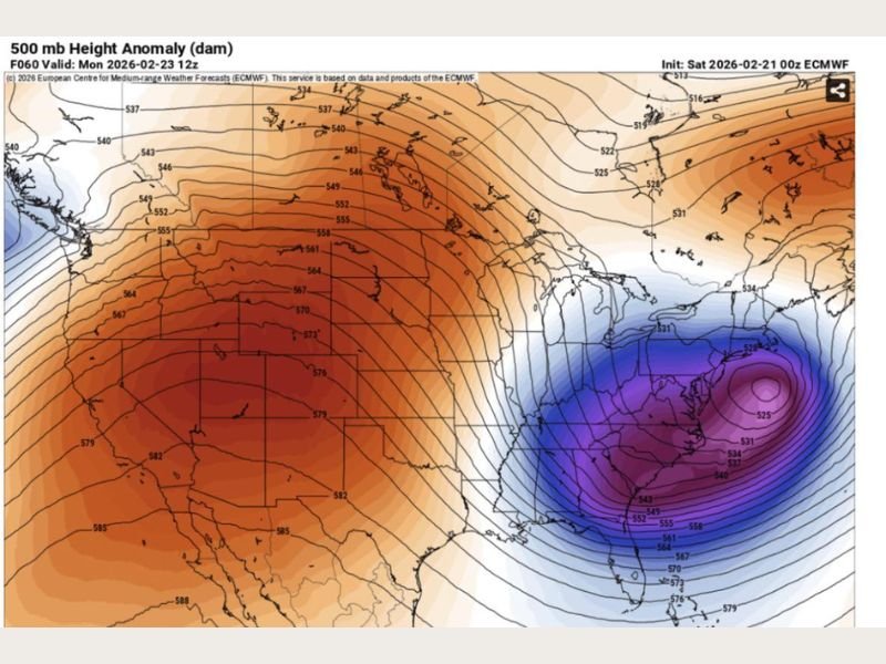
Upper-level analysis shows a strong displacement of the polar jet stream, with cold air funneling southward from Canada into the Deep South. The 500 mb height anomaly map highlights a pronounced trough over the eastern United States, signaling a deep pool of Arctic air settling over the region.
The cold intrusion is already moving into parts of the Southeast and is expected to intensify through early week, particularly late Monday and into Tuesday morning.
Freezing Temperatures Possible Along the Gulf Coast
One of the more notable aspects of this outbreak is how far south the freezing line could extend. Forecast discussions suggest freezing temperatures may reach:
- Portions of the Gulf Coast
- Inland areas of Florida
- Central and interior sections of South Florida, where lows may dip into the low 30s
Such temperatures are uncommon for these southern latitudes and could pose concerns for agriculture, exposed pipes, and sensitive vegetation.
Record Lows Possible in Several States
With anomalies running 20–30°F below average, some cities in Mississippi, Alabama, Georgia, and Florida may challenge or break daily temperature records. Overnight lows late Monday and early Tuesday are expected to be the coldest of this stretch.
Wind chills will likely make it feel even colder, especially where breezy conditions persist behind the Arctic front.
Active Pattern Continues Into Late Winter
Forecasters note that this cold blast is part of a broader active weather pattern that will persist into late February and possibly March. Another potential Polar Vortex collapse in coming weeks could trigger additional cold outbreaks and even more winter storm activity across parts of the United States.
At the same time, La Niña has officially ended, and the climate pattern is transitioning toward neutral conditions, with El Niño expected later in spring or summer. Neutral setups often allow for more temperature swings and continued volatility in the jet stream.
As Arctic air settles across the Southeast, residents in affected states should prepare for unusually cold mornings and monitor local forecasts for freeze advisories or record-breaking temperature updates.
For continued national weather coverage and in-depth analysis of major patterns affecting the country, stay updated with NapervilleLocal.com.

I’ve lived in Naperville long enough to see how quickly our community changes — from new developments downtown to sudden shifts in our Midwest weather. Reporting on Naperville news and daily forecasts gives me the chance to keep neighbors informed about what really matters. My goal is simple: deliver clear, timely updates so you always know what’s happening in our city and what to expect from the skies above.