
Post-Thanksgiving Arctic Blast Expected to Arrive, But Latest Forecast Models Show the Cold Snap Weakening Across the Midwest
UNITED STATES — Meteorologists say a late-November Arctic air outbreak remains likely in the days following Thanksgiving, but updated forecast models now show the expected cold blast weakening, especially across the Midwest and Ohio River Valley. While colder air will still enter the Lower 48, experts emphasize that such events are normal for this time of year, and current projections do not indicate anything unusually severe.
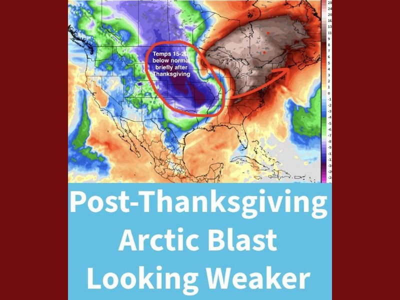
What the New Forecast Shows for the End of November
Early long-range data suggested a strong post-holiday cool-down, but multiple models have now scaled back the intensity. Forecasters say temperatures across the Plains and Midwest may still drop 15–20 degrees below normal, but the cold is expected to last only two to three days before moderating.
Meteorologists stress that this pattern is very similar to last week’s cold spell and is typical as winter approaches.
Some of the updated model shifts include:
- Less extreme cold than earlier projections
- Shorter duration of below-normal temperatures
- Limited push southward, with weaker effects below the Ohio River Valley
- Minimal impact along the Gulf Coast, where temperatures may only dip 5–10 degrees below normal briefly
The forecast map highlights the core of the cold air centered over portions of the northern Plains and Midwest.
Why Long-Range Cold Forecasts Often Look Worse Than Reality
Forecasters note that 14–21 day winter outlooks frequently exaggerate the severity of incoming cold due to limitations in long-range modeling. Just as hurricane season long-range tracks carry significant uncertainty, winter cold-season projections have similar weaknesses.
Experts highlight that:
- Long-range models inflate extreme cold signals weeks ahead
- The signals moderate as the event approaches
- More accurate temperature ranges appear 7–10 days out
This is why early model runs hinted at intense, widespread Arctic air, while the latest updates show a more typical early-winter cool-down instead of a major outbreak.
What to Expect as December Begins
Although the upcoming cold blast now appears weaker, meteorologists emphasize that the start of December reliably brings periodic Arctic fronts, and the pattern this year is no different.
Key expectations for early December:
- Short bursts of Arctic cold across the northern and central U.S.
- Occasional snow chances, especially in the Midwest and Great Lakes
- A gradual shift into more stable winter patterns
- Continued cold-front activity as seasonal norms take hold
Forecasters reassure the public that these late-November and early-December patterns are normal winter behavior, even when early model guidance initially makes them appear more severe.
More detailed temperature guidance will arrive as updated model runs become available.
For ongoing weather updates, winter travel forecasts, and Midwest climate coverage, stay connected with NapervilleLocal.com for the latest information.

I’ve lived in Naperville long enough to see how quickly our community changes — from new developments downtown to sudden shifts in our Midwest weather. Reporting on Naperville news and daily forecasts gives me the chance to keep neighbors informed about what really matters. My goal is simple: deliver clear, timely updates so you always know what’s happening in our city and what to expect from the skies above.