
Post-Winter Storm Arctic Blast Could Drive Record-Breaking Cold Across Tennessee, Alabama, Georgia, and the Carolinas
SOUTHEASTERN UNITED STATES — Forecast models are signaling a dangerous and potentially historic Arctic air outbreak immediately following the ongoing winter storm, with temperatures plunging to near-record and in some cases sub-zero levels across parts of Tennessee, Alabama, Georgia, and the Carolinas. Meteorologists say this could become the coldest air many locations have experienced in years, especially inland areas away from the coast.
Why Confidence Is Increasing in an Extreme Cold Outbreak
The latest guidance shows remarkable agreement across multiple model runs. Forecasters blended nearly 30 different model solutions, and despite small variations, the signal remains consistent: an intense Arctic air mass surges southward after the storm exits.
Even newer GFS data, described by forecasters as “absurdly cold,” continues to reinforce the idea that this is not a brief chill, but a deep and widespread cold event.
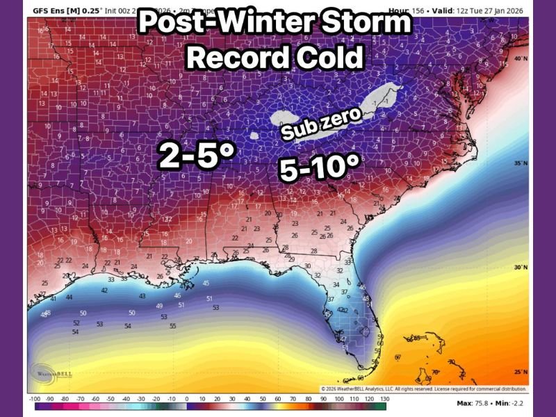
Temperature Ranges Shown in the Data
Based on the model output displayed:
- Sub-zero temperatures are possible in parts of Tennessee and the higher elevations of the southern Appalachians
- Large inland portions of Alabama and Georgia are projected to fall into the 2° to 5°F range
- Much of the Carolinas may see 5° to 10°F lows, with colder readings inland
- Coastal areas remain warmer but still significantly below normal
These values are raw temperature readings, not wind chills, meaning actual perceived cold could be even worse where winds remain elevated.
Why This Cold Is So Dangerous After a Winter Storm
This setup is especially concerning because it follows ice, snow, and freezing rain:
- Refreezing of roads is likely, even after precipitation ends
- Power restoration becomes more difficult in extreme cold
- Burst pipes become a major concern once temperatures drop into the single digits or below
- Frostbite risk increases rapidly, especially during overnight and early morning hours
In many cases, this Arctic air locks in for multiple days, delaying recovery efforts and extending hazards.
Could Records Be Broken?
Meteorologists caution that some locations may challenge or break long-standing cold records, particularly where temperatures drop below zero. While final numbers may still shift slightly, the overall magnitude of the cold is not in doubt. This is shaping up to be one of the coldest post-storm air masses the Southeast has seen in many years.
What Residents Should Prepare For
Residents across Tennessee, Alabama, Georgia, and the Carolinas should prepare for:
- Dangerously cold mornings
- Extended hard freezes
- Infrastructure stress, including water and power systems
- Increased risk to pets, livestock, and vulnerable populations
Cold of this intensity is not routine for the region, making preparation especially important.
As this Arctic blast evolves, forecast refinements will focus on exact temperature lows and duration, but the core message is already clear: severe cold is coming behind the storm.
Are you preparing for this post-storm cold surge, or have you experienced similar Arctic outbreaks in the past? Share your thoughts and stay updated with ongoing weather coverage on NapervilleLocal.com.

I’ve lived in Naperville long enough to see how quickly our community changes — from new developments downtown to sudden shifts in our Midwest weather. Reporting on Naperville news and daily forecasts gives me the chance to keep neighbors informed about what really matters. My goal is simple: deliver clear, timely updates so you always know what’s happening in our city and what to expect from the skies above.