
Powerful Arctic Air Surge Could Flip Rain to Snow Across North Georgia Monday as Winter System Sweeps the Southeast
UNITED STATES — A dramatic shift in weather is expected late Sunday night into Monday as a blast of Arctic air pushes into the eastern United States, potentially turning rain into snow or a wintry mix across parts of North Georgia and nearby regions.
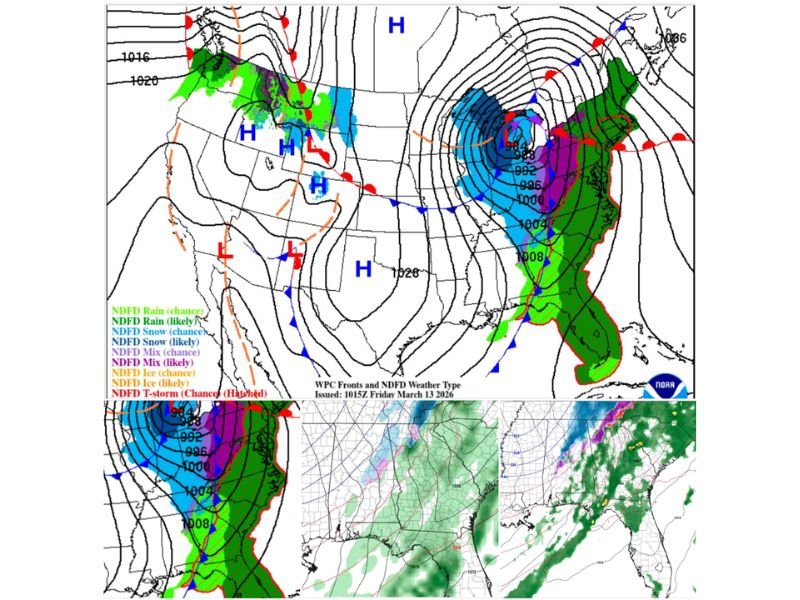
Meteorologists say the system is linked to a recent disruption in the polar vortex, allowing extremely cold Arctic air to surge southward behind a strong cold front moving across the country.
Rain Expected Ahead of the Front Before Arctic Air Arrives
As the storm system approaches the Southeast, rain will likely spread across much of the region ahead of the cold front. Moisture moving north from the Gulf of Mexico will fuel widespread precipitation across several states including Alabama, Georgia, and the Carolinas. However, conditions are expected to change rapidly once the cold Arctic air mass arrives behind the front.
Cold Air Could Trigger Snow and Wintry Mix Across North Georgia
Forecast models suggest that temperatures will drop sharply behind the front, allowing rain to transition into snow or a wintry mix across parts of North Georgia on Monday.
Weather maps currently show:
- Snow potential represented in blue
- Wintry mix areas highlighted in purple
This colder air mass could sweep across much of northern Georgia during the day Monday, raising the possibility of accumulating snow in some locations if precipitation continues while temperatures fall.
Large Storm System Driving Weather Changes
The evolving weather pattern is tied to a large low-pressure system developing over the Midwest and Great Lakes, which will pull Arctic air southward while pushing a strong frontal boundary across the eastern United States.
As this system intensifies, it will help draw cold air deep into the Southeast while spreading widespread precipitation along the front. This setup creates the potential for multiple weather hazards across the country at the same time, including rain, severe storms, and wintry conditions depending on location.
Forecast Still Developing as System Approaches
While forecast models increasingly show the possibility of snow or mixed precipitation in northern Georgia, meteorologists caution that the exact timing of the cold air arrival will determine how much winter weather develops. If the Arctic air arrives quickly enough while precipitation is still falling, some areas could see snow accumulation or icy conditions Monday. However, if the cold air arrives after the rain moves out, impacts could be more limited.
Rapid Temperature Drop Expected
The incoming Arctic air mass is expected to bring much colder temperatures across the Southeast early next week, creating a sharp contrast from the milder weather currently in place.
Residents across the region are encouraged to monitor updated forecasts closely over the next several days, as the evolving storm system and timing of the cold air surge will determine the extent of winter weather impacts across North Georgia and surrounding states.

I’ve lived in Naperville long enough to see how quickly our community changes — from new developments downtown to sudden shifts in our Midwest weather. Reporting on Naperville news and daily forecasts gives me the chance to keep neighbors informed about what really matters. My goal is simple: deliver clear, timely updates so you always know what’s happening in our city and what to expect from the skies above.